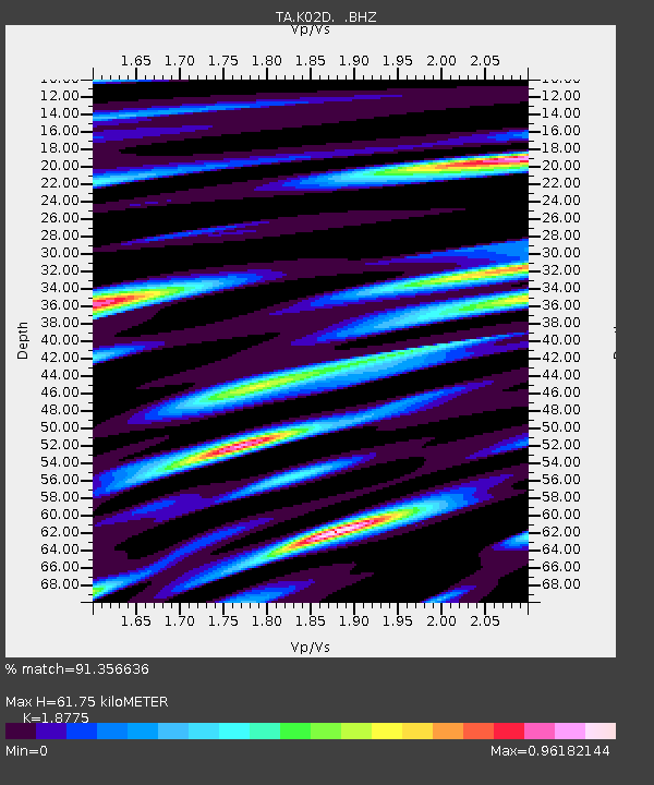
K02D Willamette Meridian, OR, USA - Earthquake Result Viewer
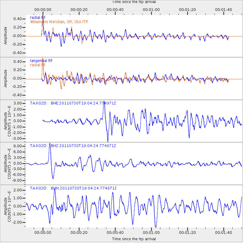
Earthquake location: Near East Coast Of Honshu, Japan
Earthquake latitude/longitude: 36.9/141.0
Earthquake time(UTC): 2011/07/30 (211) 18:53:49 GMT
Earthquake Depth: 30 km
Earthquake Magnitude: 6.4 MB, 6.0 MS, 6.5 MW, 6.4 MW
Earthquake Catalog/Contributor: WHDF/NEIC
Network: TA USArray Transportable Network (new EarthScope stations)
Station: K02D Willamette Meridian, OR, USA
Lat/Lon: 42.70 N/123.67 W
Elevation: 989 m
Distance: 69.6 deg
Az: 51.558 deg
Baz: 301.662 deg
Ray Param: 0.055513244
Estimated Moho Depth: 61.75 km
Estimated Crust Vp/Vs: 1.88
Assumed Crust Vp: 6.522 km/s
Estimated Crust Vs: 3.474 km/s
Estimated Crust Poisson's Ratio: 0.30
Radial Match: 91.356636 %
Radial Bump: 400
Transverse Match: 80.413704 %
Transverse Bump: 400
SOD ConfigId: 408116
Insert Time: 2012-01-01 01:24:28.592 +0000
GWidth: 2.5
Max Bumps: 400
Tol: 0.001

Signal To Noise

ChannelStoNSTALTA
TA:K02D: :BHZ:20110730T19:04:24.774971Z19.8338724.0252476E-62.0294814E-7
TA:K02D: :BHN:20110730T19:04:24.774971Z3.59847247.510795E-72.0872177E-7
TA:K02D: :BHE:20110730T19:04:24.774971Z6.02597571.2636158E-62.096948E-7
Arrivals
Ps8.6 SECOND
PpPs26 SECOND
PsPs/PpSs35 SECOND