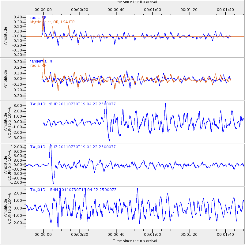
J01D Myrtle Point, OR, USA - Earthquake Result Viewer
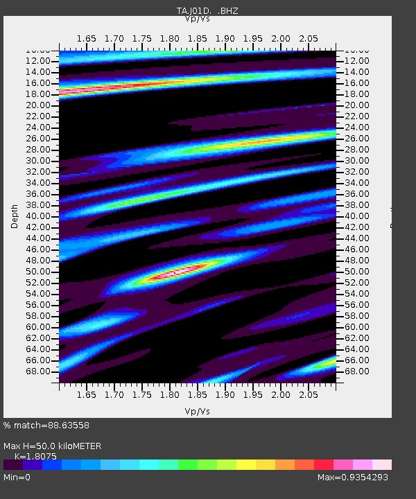
Earthquake location: Near East Coast Of Honshu, Japan
Earthquake latitude/longitude: 36.9/141.0
Earthquake time(UTC): 2011/07/30 (211) 18:53:49 GMT
Earthquake Depth: 30 km
Earthquake Magnitude: 6.4 MB, 6.0 MS, 6.5 MW, 6.4 MW
Earthquake Catalog/Contributor: WHDF/NEIC
Network: TA USArray Transportable Network (new EarthScope stations)
Station: J01D Myrtle Point, OR, USA
Lat/Lon: 43.16 N/123.93 W
Elevation: 131 m
Distance: 69.2 deg
Az: 51.243 deg
Baz: 301.37 deg
Ray Param: 0.055785175
Estimated Moho Depth: 50.0 km
Estimated Crust Vp/Vs: 1.81
Assumed Crust Vp: 6.522 km/s
Estimated Crust Vs: 3.608 km/s
Estimated Crust Poisson's Ratio: 0.28
Radial Match: 88.63558 %
Radial Bump: 400
Transverse Match: 77.114136 %
Transverse Bump: 400
SOD ConfigId: 408116
Insert Time: 2012-01-01 01:24:38.816 +0000
GWidth: 2.5
Max Bumps: 400
Tol: 0.001

Signal To Noise

ChannelStoNSTALTA
TA:J01D: :BHZ:20110730T19:04:22.250007Z13.6908715.238349E-63.8261615E-7
TA:J01D: :BHN:20110730T19:04:22.250007Z2.4669668.189843E-73.3198037E-7
TA:J01D: :BHE:20110730T19:04:22.250007Z4.54302071.4993467E-63.30033E-7
Arrivals
Ps6.4 SECOND
PpPs21 SECOND
PsPs/PpSs27 SECOND