You are here: Home > Network List > TA - USArray Transportable Network (new EarthScope stations) Stations List
> Station E32A Braaten, Kindred, ND, USA > Earthquake Result Viewer
E32A Braaten, Kindred, ND, USA - Earthquake Result Viewer
| Earthquake location: |
Near East Coast Of Honshu, Japan |
| Earthquake latitude/longitude: |
36.9/141.0 |
| Earthquake time(UTC): |
2011/07/30 (211) 18:53:49 GMT |
| Earthquake Depth: |
30 km |
| Earthquake Magnitude: |
6.4 MB, 6.0 MS, 6.5 MW, 6.4 MW |
| Earthquake Catalog/Contributor: |
WHDF/NEIC |
|
| Network: |
TA USArray Transportable Network (new EarthScope stations) |
| Station: |
E32A Braaten, Kindred, ND, USA |
| Lat/Lon: |
46.59 N/97.07 W |
| Elevation: |
297 m |
|
| Distance: |
81.9 deg |
| Az: |
36.221 deg |
| Baz: |
316.647 deg |
| Ray Param: |
0.04722075 |
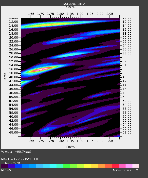
| Estimated Moho Depth: |
35.75 km |
| Estimated Crust Vp/Vs: |
1.71 |
| Assumed Crust Vp: |
6.498 km/s |
| Estimated Crust Vs: |
3.805 km/s |
| Estimated Crust Poisson's Ratio: |
0.24 |
|
| Radial Match: |
90.74661 % |
| Radial Bump: |
400 |
| Transverse Match: |
71.800995 % |
| Transverse Bump: |
400 |
| SOD ConfigId: |
408116 |
| Insert Time: |
2012-01-01 01:24:51.391 +0000 |
| GWidth: |
2.5 |
| Max Bumps: |
400 |
| Tol: |
0.001 |
|
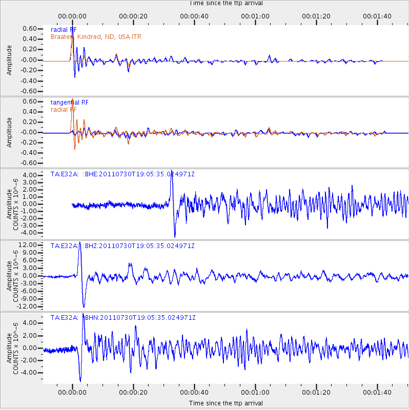
Signal To Noise
| Channel | StoN | STA | LTA |
| TA:E32A: :BHZ:20110730T19:05:35.024971Z | 41.358734 | 6.5605304E-6 | 1.5862503E-7 |
| TA:E32A: :BHN:20110730T19:05:35.024971Z | 8.1355505 | 2.4225083E-6 | 2.977682E-7 |
| TA:E32A: :BHE:20110730T19:05:35.024971Z | 10.528914 | 2.0364685E-6 | 1.9341675E-7 |
| Arrivals |
| Ps | 4.0 SECOND |
| PpPs | 14 SECOND |
| PsPs/PpSs | 18 SECOND |


