You are here: Home > Network List > TA - USArray Transportable Network (new EarthScope stations) Stations List
> Station B32A Ashes, Strandquist, MN, USA > Earthquake Result Viewer
B32A Ashes, Strandquist, MN, USA - Earthquake Result Viewer
| Earthquake location: |
Near East Coast Of Honshu, Japan |
| Earthquake latitude/longitude: |
36.9/141.0 |
| Earthquake time(UTC): |
2011/07/30 (211) 18:53:49 GMT |
| Earthquake Depth: |
30 km |
| Earthquake Magnitude: |
6.4 MB, 6.0 MS, 6.5 MW, 6.4 MW |
| Earthquake Catalog/Contributor: |
WHDF/NEIC |
|
| Network: |
TA USArray Transportable Network (new EarthScope stations) |
| Station: |
B32A Ashes, Strandquist, MN, USA |
| Lat/Lon: |
48.40 N/96.54 W |
| Elevation: |
335 m |
|
| Distance: |
80.8 deg |
| Az: |
34.704 deg |
| Baz: |
316.812 deg |
| Ray Param: |
0.047967054 |
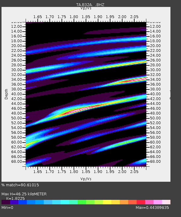
| Estimated Moho Depth: |
46.25 km |
| Estimated Crust Vp/Vs: |
1.82 |
| Assumed Crust Vp: |
6.498 km/s |
| Estimated Crust Vs: |
3.565 km/s |
| Estimated Crust Poisson's Ratio: |
0.28 |
|
| Radial Match: |
90.61015 % |
| Radial Bump: |
400 |
| Transverse Match: |
73.945244 % |
| Transverse Bump: |
400 |
| SOD ConfigId: |
408116 |
| Insert Time: |
2012-01-01 01:25:16.925 +0000 |
| GWidth: |
2.5 |
| Max Bumps: |
400 |
| Tol: |
0.001 |
|
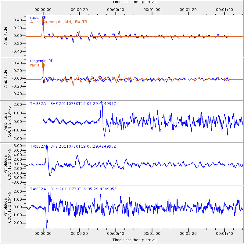
Signal To Noise
| Channel | StoN | STA | LTA |
| TA:B32A: :BHZ:20110730T19:05:29.424995Z | 20.425434 | 3.8949593E-6 | 1.9069164E-7 |
| TA:B32A: :BHN:20110730T19:05:29.424995Z | 7.2057633 | 1.1866242E-6 | 1.646771E-7 |
| TA:B32A: :BHE:20110730T19:05:29.424995Z | 6.5435424 | 1.1028546E-6 | 1.6854092E-7 |
| Arrivals |
| Ps | 6.0 SECOND |
| PpPs | 20 SECOND |
| PsPs/PpSs | 26 SECOND |


