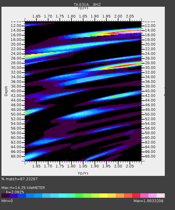
E31A Nome, ND, USA - Earthquake Result Viewer
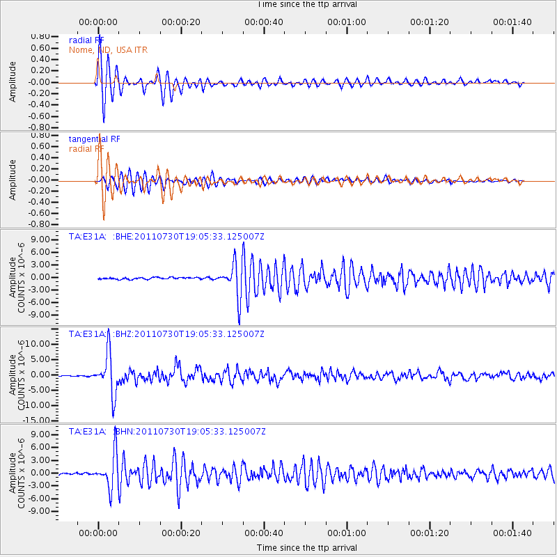
Earthquake location: Near East Coast Of Honshu, Japan
Earthquake latitude/longitude: 36.9/141.0
Earthquake time(UTC): 2011/07/30 (211) 18:53:49 GMT
Earthquake Depth: 30 km
Earthquake Magnitude: 6.4 MB, 6.0 MS, 6.5 MW, 6.4 MW
Earthquake Catalog/Contributor: WHDF/NEIC
Network: TA USArray Transportable Network (new EarthScope stations)
Station: E31A Nome, ND, USA
Lat/Lon: 46.56 N/97.89 W
Elevation: 427 m
Distance: 81.5 deg
Az: 36.658 deg
Baz: 316.118 deg
Ray Param: 0.047476504
Estimated Moho Depth: 14.25 km
Estimated Crust Vp/Vs: 2.09
Assumed Crust Vp: 6.498 km/s
Estimated Crust Vs: 3.105 km/s
Estimated Crust Poisson's Ratio: 0.35
Radial Match: 97.23287 %
Radial Bump: 281
Transverse Match: 94.107735 %
Transverse Bump: 400
SOD ConfigId: 408116
Insert Time: 2012-01-01 01:25:30.285 +0000
GWidth: 2.5
Max Bumps: 400
Tol: 0.001

Signal To Noise

ChannelStoNSTALTA
TA:E31A: :BHZ:20110730T19:05:33.125007Z58.9223826.939901E-61.17780395E-7
TA:E31A: :BHN:20110730T19:05:33.125007Z22.6563644.1423255E-61.8283275E-7
TA:E31A: :BHE:20110730T19:05:33.125007Z20.3023644.1513663E-62.04477E-7
Arrivals
Ps2.5 SECOND
PpPs6.6 SECOND
PsPs/PpSs9.1 SECOND