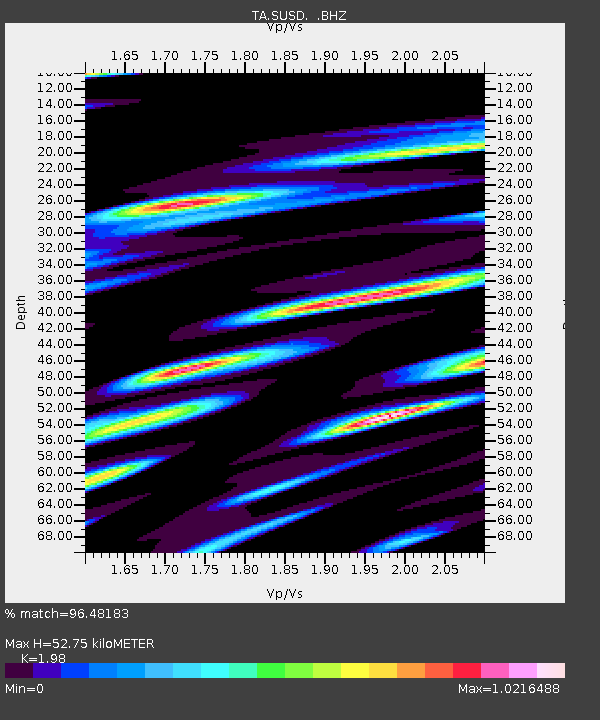
SUSD Miller, SD, USA - Earthquake Result Viewer

Earthquake location: Near East Coast Of Honshu, Japan
Earthquake latitude/longitude: 36.9/141.0
Earthquake time(UTC): 2011/07/30 (211) 18:53:49 GMT
Earthquake Depth: 30 km
Earthquake Magnitude: 6.4 MB, 6.0 MS, 6.5 MW, 6.4 MW
Earthquake Catalog/Contributor: WHDF/NEIC
Network: TA USArray Transportable Network (new EarthScope stations)
Station: SUSD Miller, SD, USA
Lat/Lon: 44.44 N/98.96 W
Elevation: 520 m
Distance: 82.5 deg
Az: 38.689 deg
Baz: 315.64 deg
Ray Param: 0.046781924
Estimated Moho Depth: 52.75 km
Estimated Crust Vp/Vs: 1.98
Assumed Crust Vp: 6.53 km/s
Estimated Crust Vs: 3.298 km/s
Estimated Crust Poisson's Ratio: 0.33
Radial Match: 96.48183 %
Radial Bump: 358
Transverse Match: 95.16764 %
Transverse Bump: 393
SOD ConfigId: 408116
Insert Time: 2012-01-01 01:26:19.166 +0000
GWidth: 2.5
Max Bumps: 400
Tol: 0.001

Signal To Noise

ChannelStoNSTALTA
TA:SUSD: :BHZ:20110730T19:05:38.32502Z63.031876.539203E-61.03744384E-7
TA:SUSD: :BHN:20110730T19:05:38.32502Z22.9235953.5739952E-61.55909E-7
TA:SUSD: :BHE:20110730T19:05:38.32502Z16.4919993.8760745E-62.3502757E-7
Arrivals
Ps8.1 SECOND
PpPs23 SECOND
PsPs/PpSs32 SECOND