You are here: Home > Network List > G - GEOSCOPE Stations List
> Station CLF Chambon la Foret observatory, France > Earthquake Result Viewer
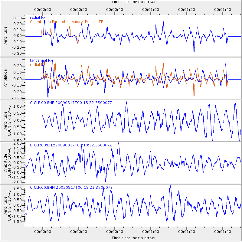
CLF Chambon la Foret observatory, France - Earthquake Result Viewer
*The percent match for this event was below the threshold and hence no stack was calculated.
| Earthquake location: |
Southwestern Ryukyu Isl., Japan |
| Earthquake latitude/longitude: |
23.5/123.5 |
| Earthquake time(UTC): |
2009/08/17 (229) 00:05:49 GMT |
| Earthquake Depth: |
20 km |
| Earthquake Magnitude: |
6.2 MB, 6.6 MS, 6.7 MW, 6.6 MW |
| Earthquake Catalog/Contributor: |
WHDF/NEIC |
|
| Network: |
G GEOSCOPE |
| Station: |
CLF Chambon la Foret observatory, France |
| Lat/Lon: |
48.03 N/2.26 E |
| Elevation: |
145 m |
|
| Distance: |
91.5 deg |
| Az: |
324.961 deg |
| Baz: |
51.738 deg |
| Ray Param: |
$rayparam |
*The percent match for this event was below the threshold and hence was not used in the summary stack. |
|
| Radial Match: |
64.589005 % |
| Radial Bump: |
334 |
| Transverse Match: |
56.32453 % |
| Transverse Bump: |
303 |
| SOD ConfigId: |
2622 |
| Insert Time: |
2010-02-26 21:53:47.044 +0000 |
| GWidth: |
2.5 |
| Max Bumps: |
400 |
| Tol: |
0.001 |
|
Signal To Noise
| Channel | StoN | STA | LTA |
| G:CLF:00:BHZ:20090817T00:18:22.350007Z | 3.0113392 | 8.73566E-7 | 2.900922E-7 |
| G:CLF:00:BHN:20090817T00:18:22.350007Z | 1.76884 | 7.063182E-7 | 3.9931152E-7 |
| G:CLF:00:BHE:20090817T00:18:22.350007Z | 1.3410995 | 5.694031E-7 | 4.2457933E-7 |
| Arrivals |
| Ps | |
| PpPs | |
| PsPs/PpSs | |


