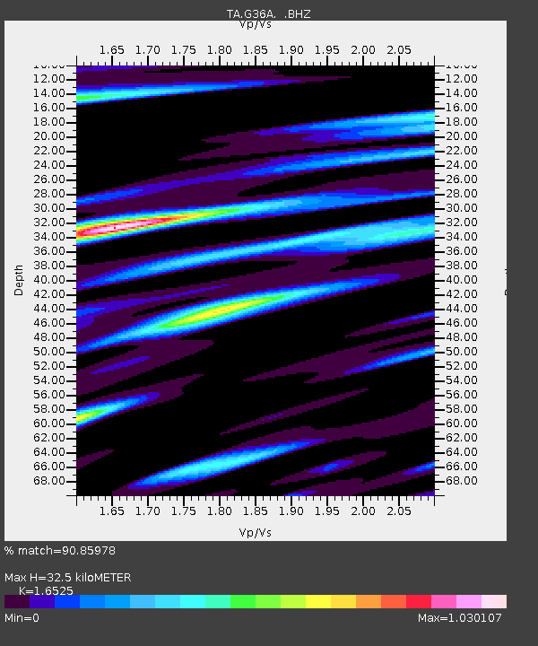
G36A St. Michael, MN, USA - Earthquake Result Viewer
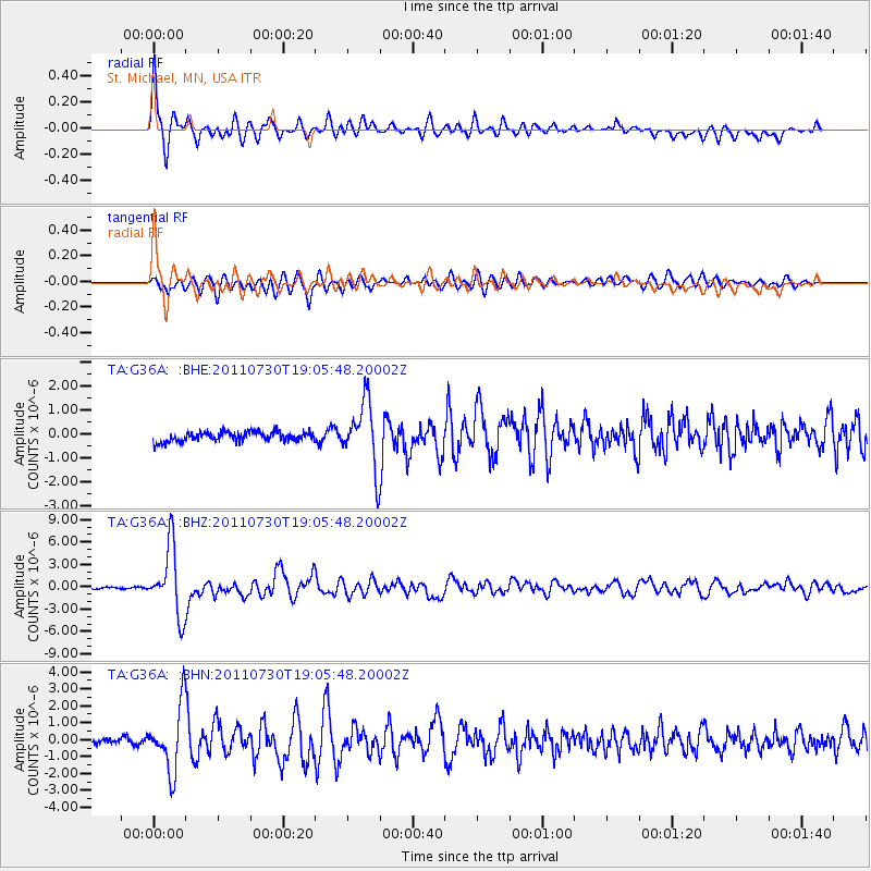
Earthquake location: Near East Coast Of Honshu, Japan
Earthquake latitude/longitude: 36.9/141.0
Earthquake time(UTC): 2011/07/30 (211) 18:53:49 GMT
Earthquake Depth: 30 km
Earthquake Magnitude: 6.4 MB, 6.0 MS, 6.5 MW, 6.4 MW
Earthquake Catalog/Contributor: WHDF/NEIC
Network: TA USArray Transportable Network (new EarthScope stations)
Station: G36A St. Michael, MN, USA
Lat/Lon: 45.23 N/93.75 W
Elevation: 293 m
Distance: 84.5 deg
Az: 35.411 deg
Baz: 318.928 deg
Ray Param: 0.045424838
Estimated Moho Depth: 32.5 km
Estimated Crust Vp/Vs: 1.65
Assumed Crust Vp: 6.571 km/s
Estimated Crust Vs: 3.976 km/s
Estimated Crust Poisson's Ratio: 0.21
Radial Match: 90.85978 %
Radial Bump: 400
Transverse Match: 80.70182 %
Transverse Bump: 400
SOD ConfigId: 408116
Insert Time: 2012-01-01 01:27:58.848 +0000
GWidth: 2.5
Max Bumps: 400
Tol: 0.001

Signal To Noise

ChannelStoNSTALTA
TA:G36A: :BHZ:20110730T19:05:48.20002Z48.66194.554785E-69.360064E-8
TA:G36A: :BHN:20110730T19:05:48.20002Z12.2832011.8774881E-61.5285006E-7
TA:G36A: :BHE:20110730T19:05:48.20002Z6.9471181.3642513E-61.9637658E-7
Arrivals
Ps3.3 SECOND
PpPs13 SECOND
PsPs/PpSs16 SECOND