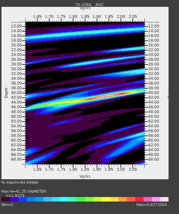
G35A Watkins, MN, USA - Earthquake Result Viewer
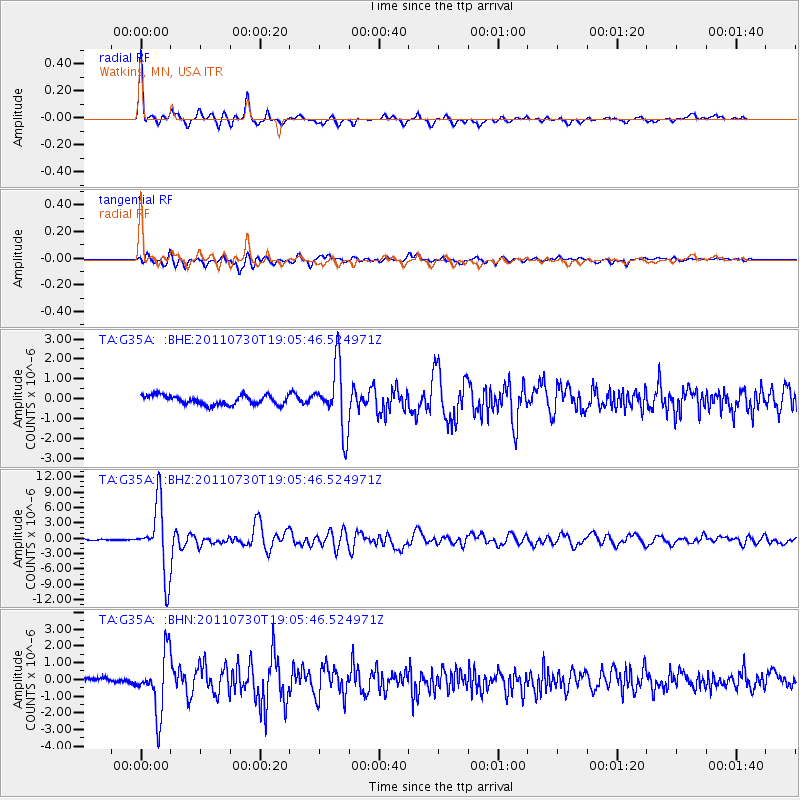
Earthquake location: Near East Coast Of Honshu, Japan
Earthquake latitude/longitude: 36.9/141.0
Earthquake time(UTC): 2011/07/30 (211) 18:53:49 GMT
Earthquake Depth: 30 km
Earthquake Magnitude: 6.4 MB, 6.0 MS, 6.5 MW, 6.4 MW
Earthquake Catalog/Contributor: WHDF/NEIC
Network: TA USArray Transportable Network (new EarthScope stations)
Station: G35A Watkins, MN, USA
Lat/Lon: 45.22 N/94.49 W
Elevation: 361 m
Distance: 84.1 deg
Az: 35.813 deg
Baz: 318.448 deg
Ray Param: 0.045659374
Estimated Moho Depth: 41.25 km
Estimated Crust Vp/Vs: 1.93
Assumed Crust Vp: 6.571 km/s
Estimated Crust Vs: 3.4 km/s
Estimated Crust Poisson's Ratio: 0.32
Radial Match: 94.94668 %
Radial Bump: 315
Transverse Match: 85.73521 %
Transverse Bump: 400
SOD ConfigId: 408116
Insert Time: 2012-01-01 01:28:10.740 +0000
GWidth: 2.5
Max Bumps: 400
Tol: 0.001

Signal To Noise

ChannelStoNSTALTA
TA:G35A: :BHZ:20110730T19:05:46.524971Z53.214636.672954E-61.2539698E-7
TA:G35A: :BHN:20110730T19:05:46.524971Z11.7912541.761853E-61.4942033E-7
TA:G35A: :BHE:20110730T19:05:46.524971Z6.93053961.5897756E-62.2938698E-7
Arrivals
Ps6.0 SECOND
PpPs18 SECOND
PsPs/PpSs24 SECOND