You are here: Home > Network List > TA - USArray Transportable Network (new EarthScope stations) Stations List
> Station H37A Dierke Farm, Cannon Falls, MN, USA > Earthquake Result Viewer
H37A Dierke Farm, Cannon Falls, MN, USA - Earthquake Result Viewer
| Earthquake location: |
Near East Coast Of Honshu, Japan |
| Earthquake latitude/longitude: |
36.9/141.0 |
| Earthquake time(UTC): |
2011/07/30 (211) 18:53:49 GMT |
| Earthquake Depth: |
30 km |
| Earthquake Magnitude: |
6.4 MB, 6.0 MS, 6.5 MW, 6.4 MW |
| Earthquake Catalog/Contributor: |
WHDF/NEIC |
|
| Network: |
TA USArray Transportable Network (new EarthScope stations) |
| Station: |
H37A Dierke Farm, Cannon Falls, MN, USA |
| Lat/Lon: |
44.58 N/92.92 W |
| Elevation: |
321 m |
|
| Distance: |
85.3 deg |
| Az: |
35.39 deg |
| Baz: |
319.512 deg |
| Ray Param: |
0.044791915 |
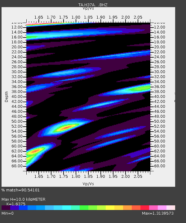
| Estimated Moho Depth: |
10.0 km |
| Estimated Crust Vp/Vs: |
1.64 |
| Assumed Crust Vp: |
6.571 km/s |
| Estimated Crust Vs: |
4.013 km/s |
| Estimated Crust Poisson's Ratio: |
0.20 |
|
| Radial Match: |
90.54181 % |
| Radial Bump: |
400 |
| Transverse Match: |
89.74858 % |
| Transverse Bump: |
400 |
| SOD ConfigId: |
408116 |
| Insert Time: |
2012-01-01 01:29:00.949 +0000 |
| GWidth: |
2.5 |
| Max Bumps: |
400 |
| Tol: |
0.001 |
|

Signal To Noise
| Channel | StoN | STA | LTA |
| TA:H37A: :BHZ:20110730T19:05:52.599983Z | 36.617012 | 6.108037E-6 | 1.6680872E-7 |
| TA:H37A: :BHN:20110730T19:05:52.599983Z | 4.7181897 | 9.233832E-7 | 1.957071E-7 |
| TA:H37A: :BHE:20110730T19:05:52.599983Z | 3.4951138 | 7.2857733E-7 | 2.0845596E-7 |
| Arrivals |
| Ps | 1.0 SECOND |
| PpPs | 3.9 SECOND |
| PsPs/PpSs | 4.9 SECOND |


