You are here: Home > Network List > TA - USArray Transportable Network (new EarthScope stations) Stations List
> Station I37A Lemond, Waseca, MN, USA > Earthquake Result Viewer
I37A Lemond, Waseca, MN, USA - Earthquake Result Viewer
| Earthquake location: |
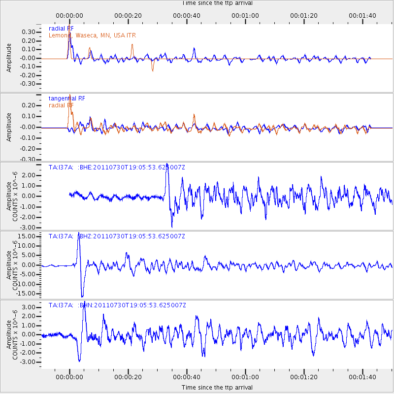
Near East Coast Of Honshu, Japan |
| Earthquake latitude/longitude: |
36.9/141.0 |
| Earthquake time(UTC): |
2011/07/30 (211) 18:53:49 GMT |
| Earthquake Depth: |
30 km |
| Earthquake Magnitude: |
6.4 MB, 6.0 MS, 6.5 MW, 6.4 MW |
| Earthquake Catalog/Contributor: |
WHDF/NEIC |
|
| Network: |
TA USArray Transportable Network (new EarthScope stations) |
| Station: |
I37A Lemond, Waseca, MN, USA |
| Lat/Lon: |
44.01 N/93.40 W |
| Elevation: |
371 m |
|
| Distance: |
85.6 deg |
| Az: |
36.023 deg |
| Baz: |
319.227 deg |
| Ray Param: |
0.044645555 |
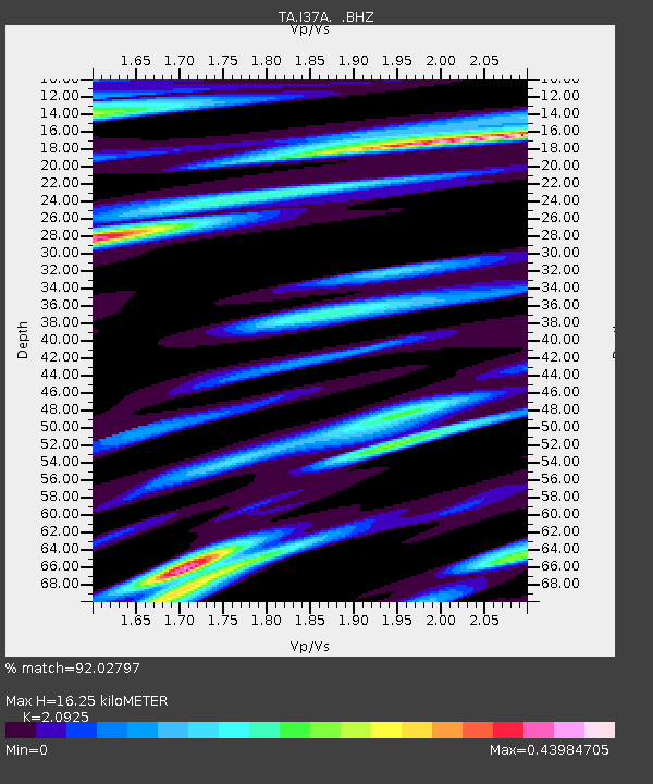
| Estimated Moho Depth: |
16.25 km |
| Estimated Crust Vp/Vs: |
2.09 |
| Assumed Crust Vp: |
6.571 km/s |
| Estimated Crust Vs: |
3.14 km/s |
| Estimated Crust Poisson's Ratio: |
0.35 |
|
| Radial Match: |
92.02797 % |
| Radial Bump: |
400 |
| Transverse Match: |
85.4008 % |
| Transverse Bump: |
400 |
| SOD ConfigId: |
408116 |
| Insert Time: |
2012-01-01 01:29:39.116 +0000 |
| GWidth: |
2.5 |
| Max Bumps: |
400 |
| Tol: |
0.001 |
|
Signal To Noise
| Channel | StoN | STA | LTA |
| TA:I37A: :BHZ:20110730T19:05:53.625007Z | 31.235271 | 8.41512E-6 | 2.694108E-7 |
| TA:I37A: :BHN:20110730T19:05:53.625007Z | 8.018774 | 1.3649637E-6 | 1.7022101E-7 |
| TA:I37A: :BHE:20110730T19:05:53.625007Z | 6.676782 | 1.2877331E-6 | 1.9286733E-7 |
| Arrivals |
| Ps | 2.8 SECOND |
| PpPs | 7.5 SECOND |
| PsPs/PpSs | 10 SECOND |


