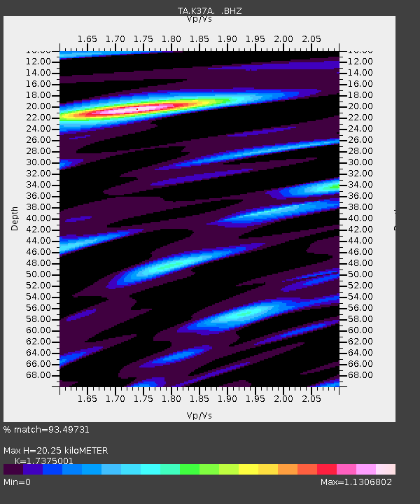
K37A Belmond, IA, USA - Earthquake Result Viewer

Earthquake location: Near East Coast Of Honshu, Japan
Earthquake latitude/longitude: 36.9/141.0
Earthquake time(UTC): 2011/07/30 (211) 18:53:49 GMT
Earthquake Depth: 30 km
Earthquake Magnitude: 6.4 MB, 6.0 MS, 6.5 MW, 6.4 MW
Earthquake Catalog/Contributor: WHDF/NEIC
Network: TA USArray Transportable Network (new EarthScope stations)
Station: K37A Belmond, IA, USA
Lat/Lon: 42.77 N/93.64 W
Elevation: 365 m
Distance: 86.4 deg
Az: 36.973 deg
Baz: 319.13 deg
Ray Param: 0.04405545
Estimated Moho Depth: 20.25 km
Estimated Crust Vp/Vs: 1.74
Assumed Crust Vp: 6.53 km/s
Estimated Crust Vs: 3.759 km/s
Estimated Crust Poisson's Ratio: 0.25
Radial Match: 93.49731 %
Radial Bump: 400
Transverse Match: 84.94839 %
Transverse Bump: 400
SOD ConfigId: 408116
Insert Time: 2012-01-01 01:29:51.580 +0000
GWidth: 2.5
Max Bumps: 400
Tol: 0.001

Signal To Noise

ChannelStoNSTALTA
TA:K37A: :BHZ:20110730T19:05:57.724983Z59.4191364.8953425E-68.238663E-8
TA:K37A: :BHN:20110730T19:05:57.724983Z12.7326141.2643284E-69.929842E-8
TA:K37A: :BHE:20110730T19:05:57.724983Z13.06226351.0115798E-67.744292E-8
Arrivals
Ps2.3 SECOND
PpPs8.3 SECOND
PsPs/PpSs11 SECOND