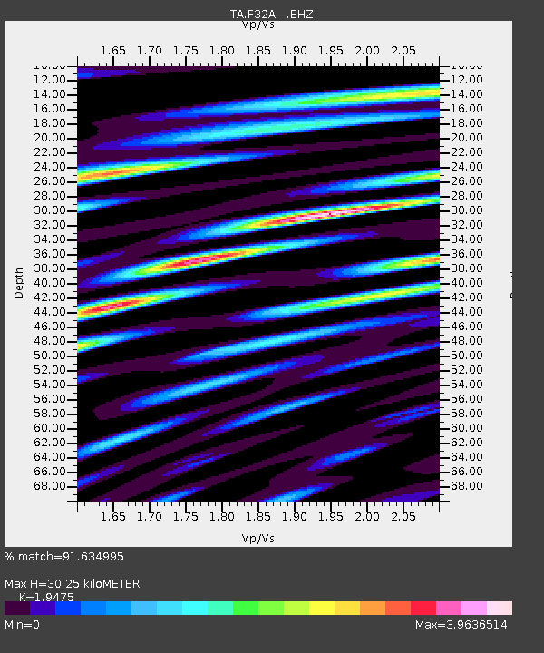
F32A Veblen, SD, USA - Earthquake Result Viewer
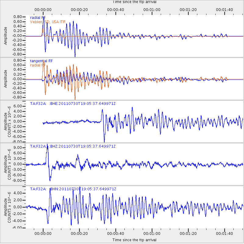
Earthquake location: Near East Coast Of Honshu, Japan
Earthquake latitude/longitude: 36.9/141.0
Earthquake time(UTC): 2011/07/30 (211) 18:53:49 GMT
Earthquake Depth: 30 km
Earthquake Magnitude: 6.4 MB, 6.0 MS, 6.5 MW, 6.4 MW
Earthquake Catalog/Contributor: WHDF/NEIC
Network: TA USArray Transportable Network (new EarthScope stations)
Station: F32A Veblen, SD, USA
Lat/Lon: 45.87 N/97.13 W
Elevation: 371 m
Distance: 82.4 deg
Az: 36.75 deg
Baz: 316.679 deg
Ray Param: 0.046874244
Estimated Moho Depth: 30.25 km
Estimated Crust Vp/Vs: 1.95
Assumed Crust Vp: 6.552 km/s
Estimated Crust Vs: 3.365 km/s
Estimated Crust Poisson's Ratio: 0.32
Radial Match: 91.634995 %
Radial Bump: 400
Transverse Match: 76.1641 %
Transverse Bump: 400
SOD ConfigId: 408116
Insert Time: 2012-01-01 01:30:18.590 +0000
GWidth: 2.5
Max Bumps: 400
Tol: 0.001

Signal To Noise

ChannelStoNSTALTA
TA:F32A: :BHZ:20110730T19:05:37.649971Z26.8315225.0726753E-61.8905656E-7
TA:F32A: :BHN:20110730T19:05:37.649971Z7.7968762.398017E-63.0756127E-7
TA:F32A: :BHE:20110730T19:05:37.649971Z8.4489792.9428581E-63.483093E-7
Arrivals
Ps4.5 SECOND
PpPs13 SECOND
PsPs/PpSs18 SECOND