You are here: Home > Network List > TA - USArray Transportable Network (new EarthScope stations) Stations List
> Station N59A State Game Land 141, Hazleton, PA, USA > Earthquake Result Viewer
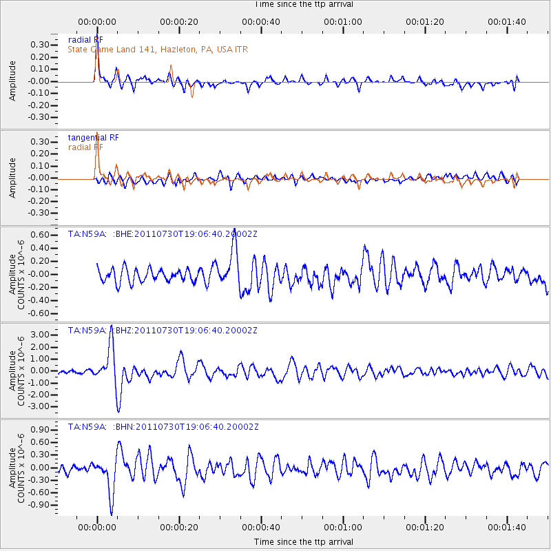
N59A State Game Land 141, Hazleton, PA, USA - Earthquake Result Viewer
| Earthquake location: |
Near East Coast Of Honshu, Japan |
| Earthquake latitude/longitude: |
36.9/141.0 |
| Earthquake time(UTC): |
2011/07/30 (211) 18:53:49 GMT |
| Earthquake Depth: |
30 km |
| Earthquake Magnitude: |
6.4 MB, 6.0 MS, 6.5 MW, 6.4 MW |
| Earthquake Catalog/Contributor: |
WHDF/NEIC |
|
| Network: |
TA USArray Transportable Network (new EarthScope stations) |
| Station: |
N59A State Game Land 141, Hazleton, PA, USA |
| Lat/Lon: |
40.92 N/75.77 W |
| Elevation: |
508 m |
|
| Distance: |
95.5 deg |
| Az: |
27.086 deg |
| Baz: |
331.226 deg |
| Ray Param: |
0.04074859 |
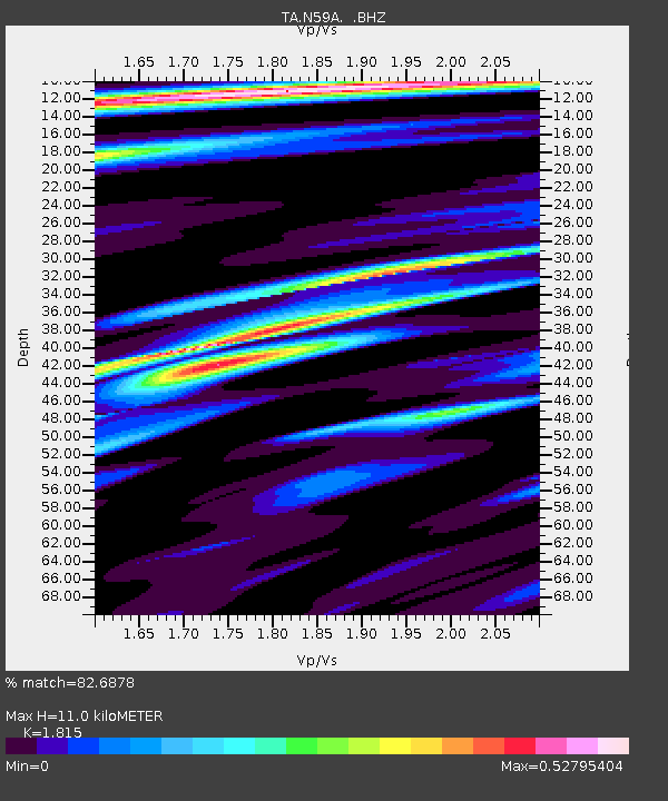
| Estimated Moho Depth: |
11.0 km |
| Estimated Crust Vp/Vs: |
1.82 |
| Assumed Crust Vp: |
6.283 km/s |
| Estimated Crust Vs: |
3.462 km/s |
| Estimated Crust Poisson's Ratio: |
0.28 |
|
| Radial Match: |
82.6878 % |
| Radial Bump: |
400 |
| Transverse Match: |
68.45347 % |
| Transverse Bump: |
400 |
| SOD ConfigId: |
408116 |
| Insert Time: |
2012-01-01 01:31:07.271 +0000 |
| GWidth: |
2.5 |
| Max Bumps: |
400 |
| Tol: |
0.001 |
|
Signal To Noise
| Channel | StoN | STA | LTA |
| TA:N59A: :BHZ:20110730T19:06:40.20002Z | 10.957843 | 1.6466523E-6 | 1.5027157E-7 |
| TA:N59A: :BHN:20110730T19:06:40.20002Z | 3.5107734 | 4.4031717E-7 | 1.2541885E-7 |
| TA:N59A: :BHE:20110730T19:06:40.20002Z | 3.1604686 | 3.0202077E-7 | 9.556202E-8 |
| Arrivals |
| Ps | 1.5 SECOND |
| PpPs | 4.8 SECOND |
| PsPs/PpSs | 6.3 SECOND |


