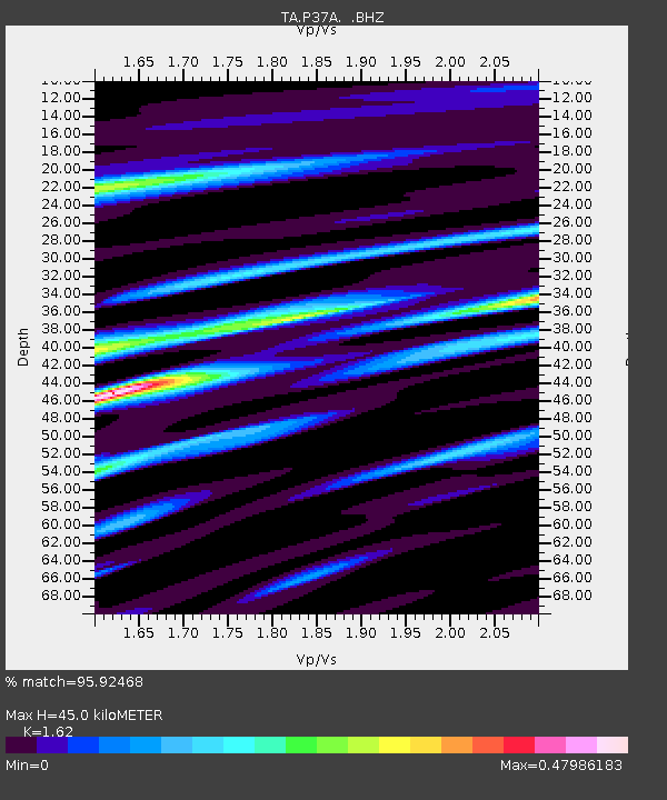
P37A Lathrop, MO, USA - Earthquake Result Viewer

Earthquake location: Near East Coast Of Honshu, Japan
Earthquake latitude/longitude: 36.9/141.0
Earthquake time(UTC): 2011/07/30 (211) 18:53:49 GMT
Earthquake Depth: 30 km
Earthquake Magnitude: 6.4 MB, 6.0 MS, 6.5 MW, 6.4 MW
Earthquake Catalog/Contributor: WHDF/NEIC
Network: TA USArray Transportable Network (new EarthScope stations)
Station: P37A Lathrop, MO, USA
Lat/Lon: 39.59 N/94.35 W
Elevation: 300 m
Distance: 88.4 deg
Az: 39.465 deg
Baz: 318.777 deg
Ray Param: 0.0425594
Estimated Moho Depth: 45.0 km
Estimated Crust Vp/Vs: 1.62
Assumed Crust Vp: 6.498 km/s
Estimated Crust Vs: 4.011 km/s
Estimated Crust Poisson's Ratio: 0.19
Radial Match: 95.92468 %
Radial Bump: 320
Transverse Match: 86.576485 %
Transverse Bump: 400
SOD ConfigId: 408116
Insert Time: 2012-01-01 01:31:44.368 +0000
GWidth: 2.5
Max Bumps: 400
Tol: 0.001

Signal To Noise

ChannelStoNSTALTA
TA:P37A: :BHZ:20110730T19:06:07.524971Z64.449764.7281414E-67.336167E-8
TA:P37A: :BHN:20110730T19:06:07.524971Z17.3166921.1698811E-66.7558E-8
TA:P37A: :BHE:20110730T19:06:07.524971Z18.4961381.1297938E-66.108269E-8
Arrivals
Ps4.4 SECOND
PpPs18 SECOND
PsPs/PpSs22 SECOND