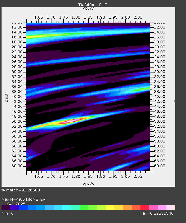
S40A Lebanon, MO, USA - Earthquake Result Viewer

Earthquake location: Near East Coast Of Honshu, Japan
Earthquake latitude/longitude: 36.9/141.0
Earthquake time(UTC): 2011/07/30 (211) 18:53:49 GMT
Earthquake Depth: 30 km
Earthquake Magnitude: 6.4 MB, 6.0 MS, 6.5 MW, 6.4 MW
Earthquake Catalog/Contributor: WHDF/NEIC
Network: TA USArray Transportable Network (new EarthScope stations)
Station: S40A Lebanon, MO, USA
Lat/Lon: 37.60 N/92.50 W
Elevation: 336 m
Distance: 90.9 deg
Az: 39.66 deg
Baz: 319.927 deg
Ray Param: 0.041638736
Estimated Moho Depth: 49.5 km
Estimated Crust Vp/Vs: 1.78
Assumed Crust Vp: 6.53 km/s
Estimated Crust Vs: 3.664 km/s
Estimated Crust Poisson's Ratio: 0.27
Radial Match: 91.26683 %
Radial Bump: 273
Transverse Match: 76.84657 %
Transverse Bump: 400
SOD ConfigId: 408116
Insert Time: 2012-01-01 01:32:42.127 +0000
GWidth: 2.5
Max Bumps: 400
Tol: 0.001

Signal To Noise

ChannelStoNSTALTA
TA:S40A: :BHZ:20110730T19:06:18.95002Z33.560272.767781E-68.247196E-8
TA:S40A: :BHN:20110730T19:06:18.95002Z11.3914296.63861E-75.8277237E-8
TA:S40A: :BHE:20110730T19:06:18.95002Z7.01417885.3874624E-77.680817E-8
Arrivals
Ps6.1 SECOND
PpPs21 SECOND
PsPs/PpSs27 SECOND