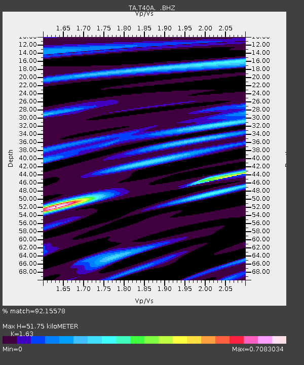
T40A Mansfield, MO, USA - Earthquake Result Viewer
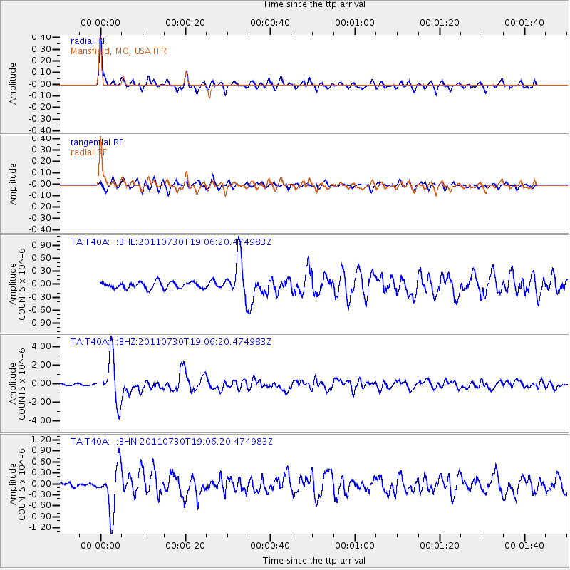
Earthquake location: Near East Coast Of Honshu, Japan
Earthquake latitude/longitude: 36.9/141.0
Earthquake time(UTC): 2011/07/30 (211) 18:53:49 GMT
Earthquake Depth: 30 km
Earthquake Magnitude: 6.4 MB, 6.0 MS, 6.5 MW, 6.4 MW
Earthquake Catalog/Contributor: WHDF/NEIC
Network: TA USArray Transportable Network (new EarthScope stations)
Station: T40A Mansfield, MO, USA
Lat/Lon: 37.15 N/92.52 W
Elevation: 399 m
Distance: 91.2 deg
Az: 39.959 deg
Baz: 319.91 deg
Ray Param: 0.041614965
Estimated Moho Depth: 51.75 km
Estimated Crust Vp/Vs: 1.63
Assumed Crust Vp: 6.53 km/s
Estimated Crust Vs: 4.006 km/s
Estimated Crust Poisson's Ratio: 0.20
Radial Match: 92.15578 %
Radial Bump: 347
Transverse Match: 82.11408 %
Transverse Bump: 400
SOD ConfigId: 408116
Insert Time: 2012-01-01 01:32:48.192 +0000
GWidth: 2.5
Max Bumps: 400
Tol: 0.001

Signal To Noise

ChannelStoNSTALTA
TA:T40A: :BHZ:20110730T19:06:20.474983Z27.5909352.3965342E-68.685948E-8
TA:T40A: :BHN:20110730T19:06:20.474983Z13.4202526.218708E-74.6338236E-8
TA:T40A: :BHE:20110730T19:06:20.474983Z6.8271364.867773E-77.130036E-8
Arrivals
Ps5.1 SECOND
PpPs20 SECOND
PsPs/PpSs25 SECOND