You are here: Home > Network List > TA - USArray Transportable Network (new EarthScope stations) Stations List
> Station Y45A Yeager Farm, Coffeeville, MS, USA > Earthquake Result Viewer
Y45A Yeager Farm, Coffeeville, MS, USA - Earthquake Result Viewer
| Earthquake location: |
Near East Coast Of Honshu, Japan |
| Earthquake latitude/longitude: |
36.9/141.0 |
| Earthquake time(UTC): |
2011/07/30 (211) 18:53:49 GMT |
| Earthquake Depth: |
30 km |
| Earthquake Magnitude: |
6.4 MB, 6.0 MS, 6.5 MW, 6.4 MW |
| Earthquake Catalog/Contributor: |
WHDF/NEIC |
|
| Network: |
TA USArray Transportable Network (new EarthScope stations) |
| Station: |
Y45A Yeager Farm, Coffeeville, MS, USA |
| Lat/Lon: |
33.87 N/89.54 W |
| Elevation: |
106 m |
|
| Distance: |
95.3 deg |
| Az: |
40.151 deg |
| Baz: |
321.621 deg |
| Ray Param: |
0.040811043 |
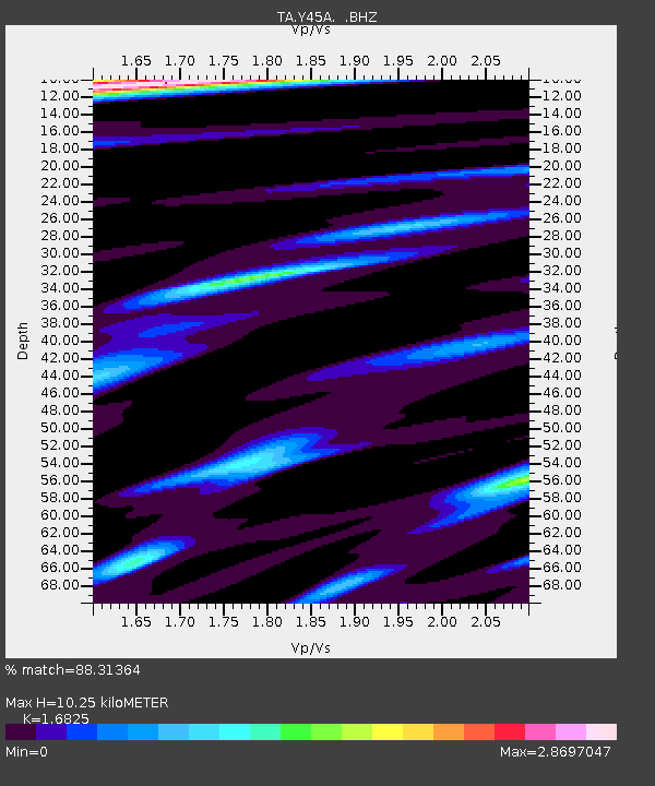
| Estimated Moho Depth: |
10.25 km |
| Estimated Crust Vp/Vs: |
1.68 |
| Assumed Crust Vp: |
6.201 km/s |
| Estimated Crust Vs: |
3.686 km/s |
| Estimated Crust Poisson's Ratio: |
0.23 |
|
| Radial Match: |
88.31364 % |
| Radial Bump: |
368 |
| Transverse Match: |
81.4872 % |
| Transverse Bump: |
368 |
| SOD ConfigId: |
408116 |
| Insert Time: |
2012-01-01 01:38:02.288 +0000 |
| GWidth: |
2.5 |
| Max Bumps: |
400 |
| Tol: |
0.001 |
|
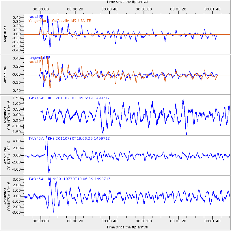
Signal To Noise
| Channel | StoN | STA | LTA |
| TA:Y45A: :BHZ:20110730T19:06:39.149971Z | 17.235361 | 2.4616643E-6 | 1.4282638E-7 |
| TA:Y45A: :BHN:20110730T19:06:39.149971Z | 3.4228523 | 8.415115E-7 | 2.4585097E-7 |
| TA:Y45A: :BHE:20110730T19:06:39.149971Z | 1.7283252 | 5.46366E-7 | 3.161245E-7 |
| Arrivals |
| Ps | 1.2 SECOND |
| PpPs | 4.3 SECOND |
| PsPs/PpSs | 5.5 SECOND |


