You are here: Home > Network List > TA - USArray Transportable Network (new EarthScope stations) Stations List
> Station Z43A Armstrong Family, Eudora, AR, USA > Earthquake Result Viewer
Z43A Armstrong Family, Eudora, AR, USA - Earthquake Result Viewer
| Earthquake location: |
Near East Coast Of Honshu, Japan |
| Earthquake latitude/longitude: |
36.9/141.0 |
| Earthquake time(UTC): |
2011/07/30 (211) 18:53:49 GMT |
| Earthquake Depth: |
30 km |
| Earthquake Magnitude: |
6.4 MB, 6.0 MS, 6.5 MW, 6.4 MW |
| Earthquake Catalog/Contributor: |
WHDF/NEIC |
|
| Network: |
TA USArray Transportable Network (new EarthScope stations) |
| Station: |
Z43A Armstrong Family, Eudora, AR, USA |
| Lat/Lon: |
33.21 N/91.24 W |
| Elevation: |
39 m |
|
| Distance: |
94.9 deg |
| Az: |
41.673 deg |
| Baz: |
320.551 deg |
| Ray Param: |
0.04091291 |
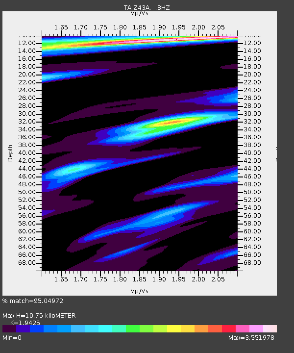
| Estimated Moho Depth: |
10.75 km |
| Estimated Crust Vp/Vs: |
1.94 |
| Assumed Crust Vp: |
6.201 km/s |
| Estimated Crust Vs: |
3.193 km/s |
| Estimated Crust Poisson's Ratio: |
0.32 |
|
| Radial Match: |
95.04972 % |
| Radial Bump: |
306 |
| Transverse Match: |
81.897705 % |
| Transverse Bump: |
400 |
| SOD ConfigId: |
408116 |
| Insert Time: |
2012-01-01 01:38:31.981 +0000 |
| GWidth: |
2.5 |
| Max Bumps: |
400 |
| Tol: |
0.001 |
|

Signal To Noise
| Channel | StoN | STA | LTA |
| TA:Z43A: :BHZ:20110730T19:06:37.399971Z | 16.3326 | 2.1936607E-6 | 1.3431179E-7 |
| TA:Z43A: :BHN:20110730T19:06:37.399971Z | 2.8035054 | 8.6488023E-7 | 3.0849958E-7 |
| TA:Z43A: :BHE:20110730T19:06:37.399971Z | 2.5203476 | 6.3105807E-7 | 2.5038534E-7 |
| Arrivals |
| Ps | 1.7 SECOND |
| PpPs | 5.0 SECOND |
| PsPs/PpSs | 6.7 SECOND |


