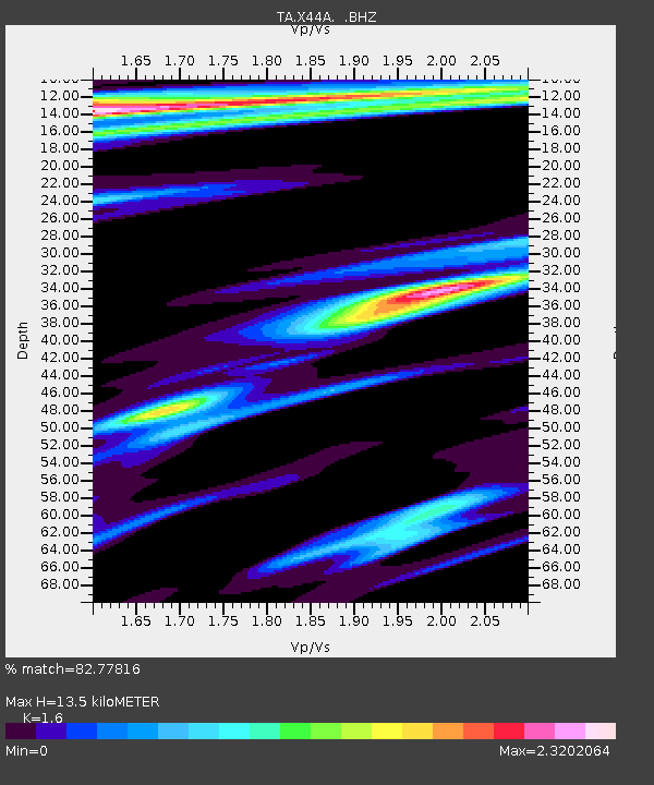
X44A Crenshaw, MS, USA - Earthquake Result Viewer
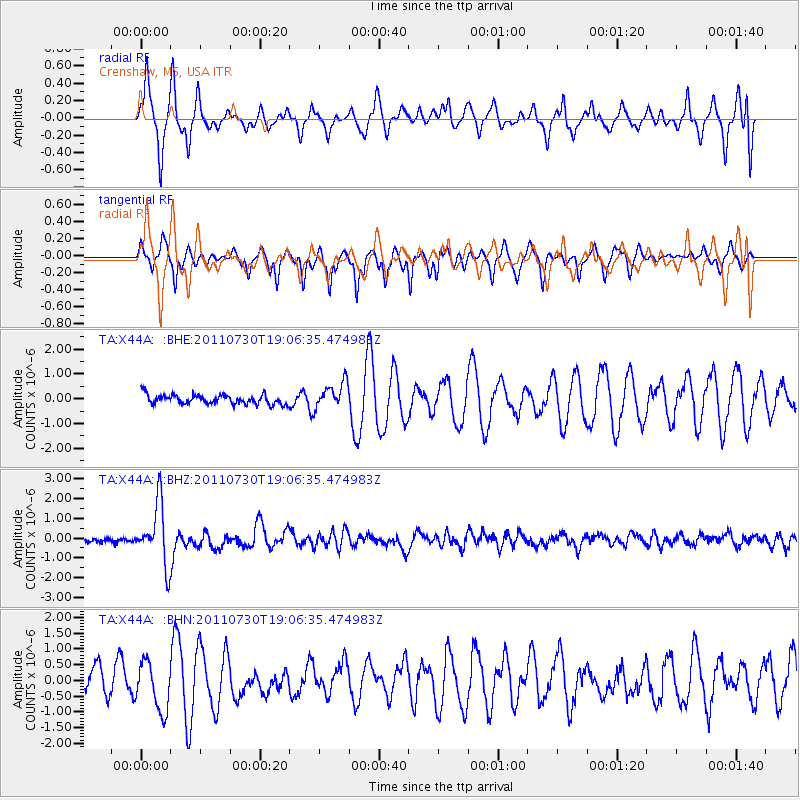
Earthquake location: Near East Coast Of Honshu, Japan
Earthquake latitude/longitude: 36.9/141.0
Earthquake time(UTC): 2011/07/30 (211) 18:53:49 GMT
Earthquake Depth: 30 km
Earthquake Magnitude: 6.4 MB, 6.0 MS, 6.5 MW, 6.4 MW
Earthquake Catalog/Contributor: WHDF/NEIC
Network: TA USArray Transportable Network (new EarthScope stations)
Station: X44A Crenshaw, MS, USA
Lat/Lon: 34.50 N/90.15 W
Elevation: 109 m
Distance: 94.5 deg
Az: 40.148 deg
Baz: 321.284 deg
Ray Param: 0.041023396
Estimated Moho Depth: 13.5 km
Estimated Crust Vp/Vs: 1.60
Assumed Crust Vp: 6.273 km/s
Estimated Crust Vs: 3.921 km/s
Estimated Crust Poisson's Ratio: 0.18
Radial Match: 82.77816 %
Radial Bump: 400
Transverse Match: 80.01545 %
Transverse Bump: 338
SOD ConfigId: 408116
Insert Time: 2012-01-01 01:39:02.621 +0000
GWidth: 2.5
Max Bumps: 400
Tol: 0.001

Signal To Noise

ChannelStoNSTALTA
TA:X44A: :BHZ:20110730T19:06:35.474983Z12.111741.5309707E-61.2640386E-7
TA:X44A: :BHN:20110730T19:06:35.474983Z1.9811957.760954E-73.9173094E-7
TA:X44A: :BHE:20110730T19:06:35.474983Z2.76413155.236645E-71.894499E-7
Arrivals
Ps1.3 SECOND
PpPs5.5 SECOND
PsPs/PpSs6.8 SECOND