P39B Salisbury, MO, USA - Earthquake Result Viewer
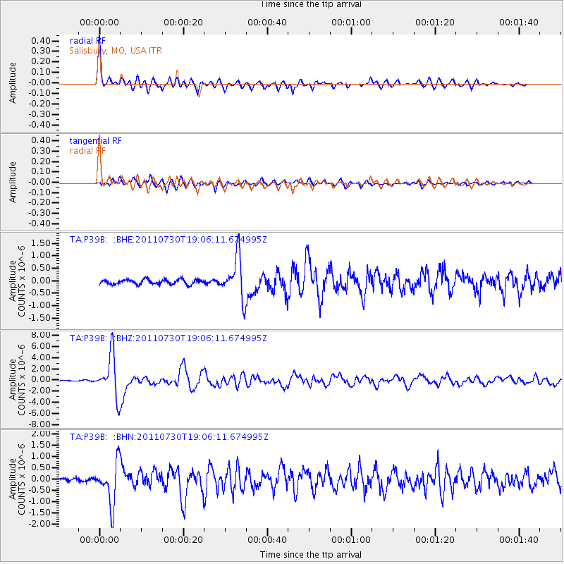
Earthquake location: Near East Coast Of Honshu, Japan
Earthquake latitude/longitude: 36.9/141.0
Earthquake time(UTC): 2011/07/30 (211) 18:53:49 GMT
Earthquake Depth: 30 km
Earthquake Magnitude: 6.4 MB, 6.0 MS, 6.5 MW, 6.4 MW
Earthquake Catalog/Contributor: WHDF/NEIC
Network: TA USArray Transportable Network (new EarthScope stations)
Station: P39B Salisbury, MO, USA
Lat/Lon: 39.49 N/92.75 W
Elevation: 226 m
Distance: 89.3 deg
Az: 38.596 deg
Baz: 319.771 deg
Ray Param: 0.04191084
Estimated Moho Depth: 22.75 km
Estimated Crust Vp/Vs: 1.70
Assumed Crust Vp: 6.498 km/s
Estimated Crust Vs: 3.828 km/s
Estimated Crust Poisson's Ratio: 0.23
Radial Match: 95.58497 %
Radial Bump: 339
Transverse Match: 88.9743 %
Transverse Bump: 400
SOD ConfigId: 408116
Insert Time: 2012-01-01 01:39:08.033 +0000
GWidth: 2.5
Max Bumps: 400
Tol: 0.001

Signal To Noise

ChannelStoNSTALTA
TA:P39B: :BHZ:20110730T19:06:11.674995Z59.265213.903394E-66.5863155E-8
TA:P39B: :BHN:20110730T19:06:11.674995Z13.8181059.636811E-76.974047E-8
TA:P39B: :BHE:20110730T19:06:11.674995Z9.4227218.7392607E-79.274668E-8
Arrivals
Ps2.5 SECOND
PpPs9.2 SECOND
PsPs/PpSs12 SECOND