You are here: Home > Network List > TA - USArray Transportable Network (new EarthScope stations) Stations List
> Station W44A Shelby Farms Park, Memphis, TN, USA > Earthquake Result Viewer
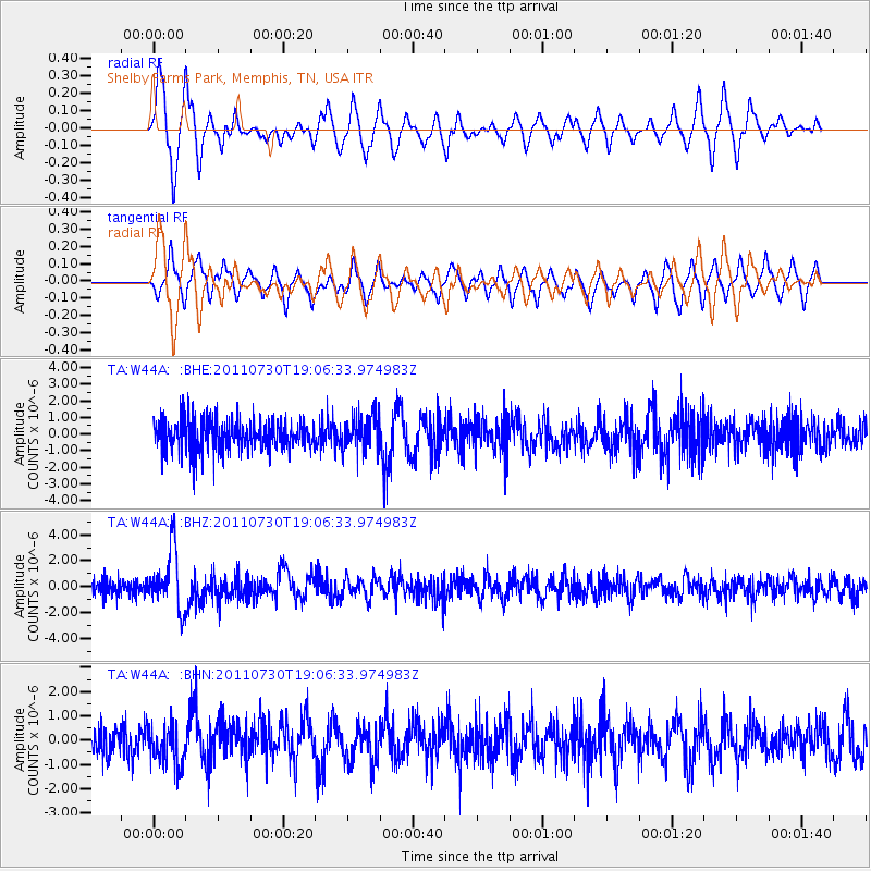
W44A Shelby Farms Park, Memphis, TN, USA - Earthquake Result Viewer
| Earthquake location: |
Near East Coast Of Honshu, Japan |
| Earthquake latitude/longitude: |
36.9/141.0 |
| Earthquake time(UTC): |
2011/07/30 (211) 18:53:49 GMT |
| Earthquake Depth: |
30 km |
| Earthquake Magnitude: |
6.4 MB, 6.0 MS, 6.5 MW, 6.4 MW |
| Earthquake Catalog/Contributor: |
WHDF/NEIC |
|
| Network: |
TA USArray Transportable Network (new EarthScope stations) |
| Station: |
W44A Shelby Farms Park, Memphis, TN, USA |
| Lat/Lon: |
35.14 N/89.82 W |
| Elevation: |
101 m |
|
| Distance: |
94.1 deg |
| Az: |
39.536 deg |
| Baz: |
321.518 deg |
| Ray Param: |
0.041100483 |
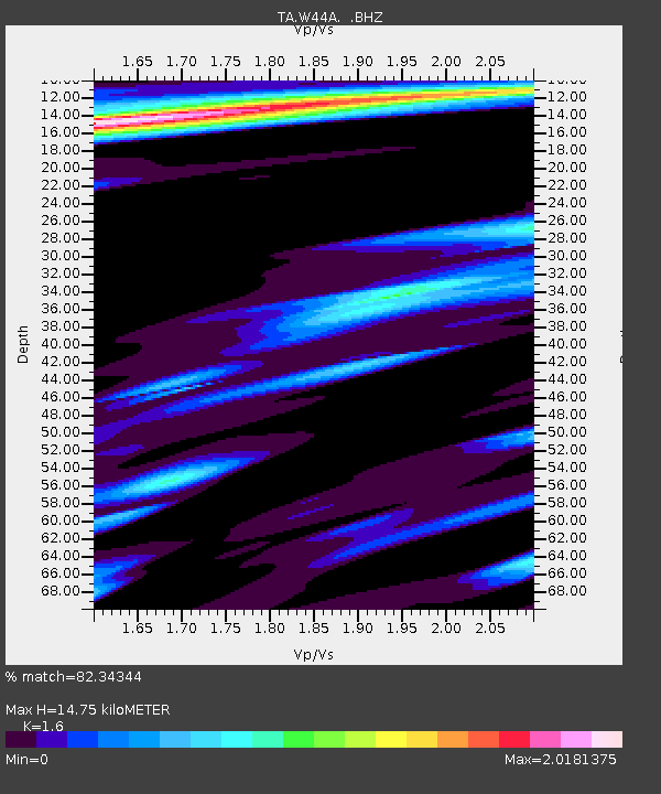
| Estimated Moho Depth: |
14.75 km |
| Estimated Crust Vp/Vs: |
1.60 |
| Assumed Crust Vp: |
6.38 km/s |
| Estimated Crust Vs: |
3.988 km/s |
| Estimated Crust Poisson's Ratio: |
0.18 |
|
| Radial Match: |
82.34344 % |
| Radial Bump: |
376 |
| Transverse Match: |
81.077835 % |
| Transverse Bump: |
376 |
| SOD ConfigId: |
408116 |
| Insert Time: |
2012-01-01 01:39:26.173 +0000 |
| GWidth: |
2.5 |
| Max Bumps: |
400 |
| Tol: |
0.001 |
|
Signal To Noise
| Channel | StoN | STA | LTA |
| TA:W44A: :BHZ:20110730T19:06:33.974983Z | 3.6380787 | 2.2073634E-6 | 6.067388E-7 |
| TA:W44A: :BHN:20110730T19:06:33.974983Z | 1.2982087 | 8.218586E-7 | 6.3307124E-7 |
| TA:W44A: :BHE:20110730T19:06:33.974983Z | 1.0986642 | 1.0416271E-6 | 9.480851E-7 |
| Arrivals |
| Ps | 1.4 SECOND |
| PpPs | 5.9 SECOND |
| PsPs/PpSs | 7.3 SECOND |


