You are here: Home > Network List > TA - USArray Transportable Network (new EarthScope stations) Stations List
> Station X45A UM Field Station, Abbeville, MS, USA > Earthquake Result Viewer
X45A UM Field Station, Abbeville, MS, USA - Earthquake Result Viewer
| Earthquake location: |
Near East Coast Of Honshu, Japan |
| Earthquake latitude/longitude: |
36.9/141.0 |
| Earthquake time(UTC): |
2011/07/30 (211) 18:53:49 GMT |
| Earthquake Depth: |
30 km |
| Earthquake Magnitude: |
6.4 MB, 6.0 MS, 6.5 MW, 6.4 MW |
| Earthquake Catalog/Contributor: |
WHDF/NEIC |
|
| Network: |
TA USArray Transportable Network (new EarthScope stations) |
| Station: |
X45A UM Field Station, Abbeville, MS, USA |
| Lat/Lon: |
34.42 N/89.39 W |
| Elevation: |
142 m |
|
| Distance: |
94.9 deg |
| Az: |
39.706 deg |
| Baz: |
321.745 deg |
| Ray Param: |
0.040906608 |
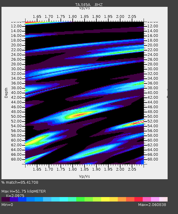
| Estimated Moho Depth: |
51.75 km |
| Estimated Crust Vp/Vs: |
2.10 |
| Assumed Crust Vp: |
6.38 km/s |
| Estimated Crust Vs: |
3.042 km/s |
| Estimated Crust Poisson's Ratio: |
0.35 |
|
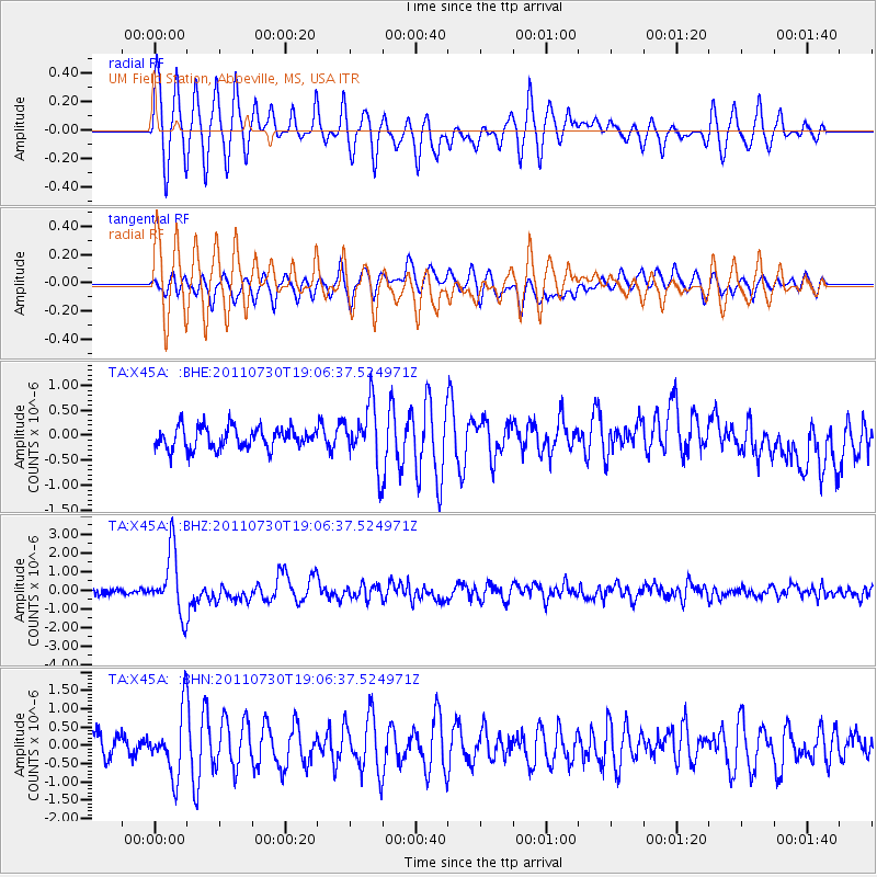
| Radial Match: |
85.41708 % |
| Radial Bump: |
400 |
| Transverse Match: |
70.20892 % |
| Transverse Bump: |
400 |
| SOD ConfigId: |
408116 |
| Insert Time: |
2012-01-01 01:39:44.749 +0000 |
| GWidth: |
2.5 |
| Max Bumps: |
400 |
| Tol: |
0.001 |
|
Signal To Noise
| Channel | StoN | STA | LTA |
| TA:X45A: :BHZ:20110730T19:06:37.524971Z | 13.070174 | 1.6573724E-6 | 1.2680569E-7 |
| TA:X45A: :BHN:20110730T19:06:37.524971Z | 3.4123263 | 8.6298115E-7 | 2.5290112E-7 |
| TA:X45A: :BHE:20110730T19:06:37.524971Z | 2.7691865 | 5.919945E-7 | 2.137792E-7 |
| Arrivals |
| Ps | 9.1 SECOND |
| PpPs | 25 SECOND |
| PsPs/PpSs | 34 SECOND |


