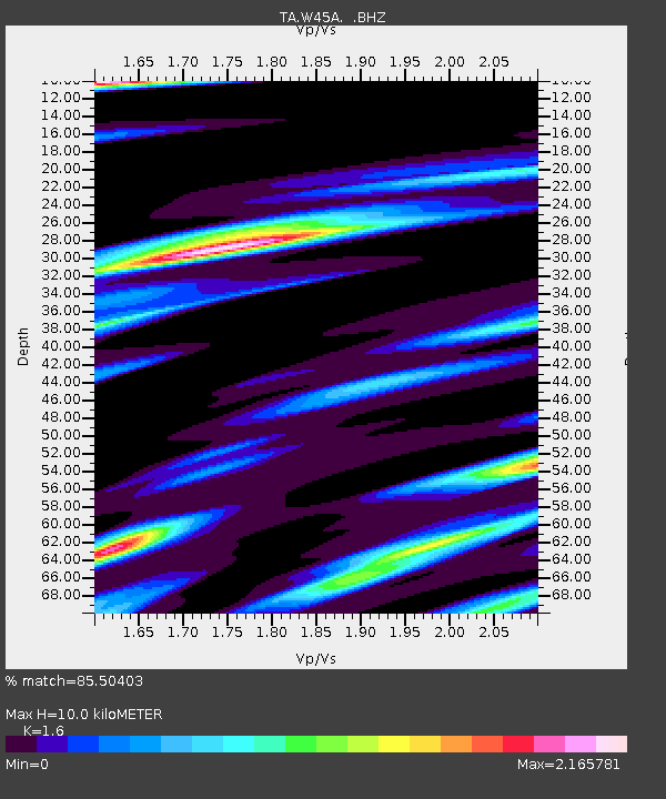
W45A Hickory Valley, TN, USA - Earthquake Result Viewer

Earthquake location: Near East Coast Of Honshu, Japan
Earthquake latitude/longitude: 36.9/141.0
Earthquake time(UTC): 2011/07/30 (211) 18:53:49 GMT
Earthquake Depth: 30 km
Earthquake Magnitude: 6.4 MB, 6.0 MS, 6.5 MW, 6.4 MW
Earthquake Catalog/Contributor: WHDF/NEIC
Network: TA USArray Transportable Network (new EarthScope stations)
Station: W45A Hickory Valley, TN, USA
Lat/Lon: 35.16 N/89.19 W
Elevation: 187 m
Distance: 94.5 deg
Az: 39.119 deg
Baz: 321.91 deg
Ray Param: 0.041028768
Estimated Moho Depth: 10.0 km
Estimated Crust Vp/Vs: 1.60
Assumed Crust Vp: 6.38 km/s
Estimated Crust Vs: 3.988 km/s
Estimated Crust Poisson's Ratio: 0.18
Radial Match: 85.50403 %
Radial Bump: 400
Transverse Match: 66.671425 %
Transverse Bump: 400
SOD ConfigId: 408116
Insert Time: 2012-01-01 01:39:51.801 +0000
GWidth: 2.5
Max Bumps: 400
Tol: 0.001

Signal To Noise

ChannelStoNSTALTA
TA:W45A: :BHZ:20110730T19:06:35.375007Z14.2074591.566276E-61.1024321E-7
TA:W45A: :BHN:20110730T19:06:35.375007Z2.36299047.564891E-73.2014057E-7
TA:W45A: :BHE:20110730T19:06:35.375007Z2.6818485.844514E-72.179286E-7
Arrivals
Ps1.0 SECOND
PpPs4.0 SECOND
PsPs/PpSs4.9 SECOND