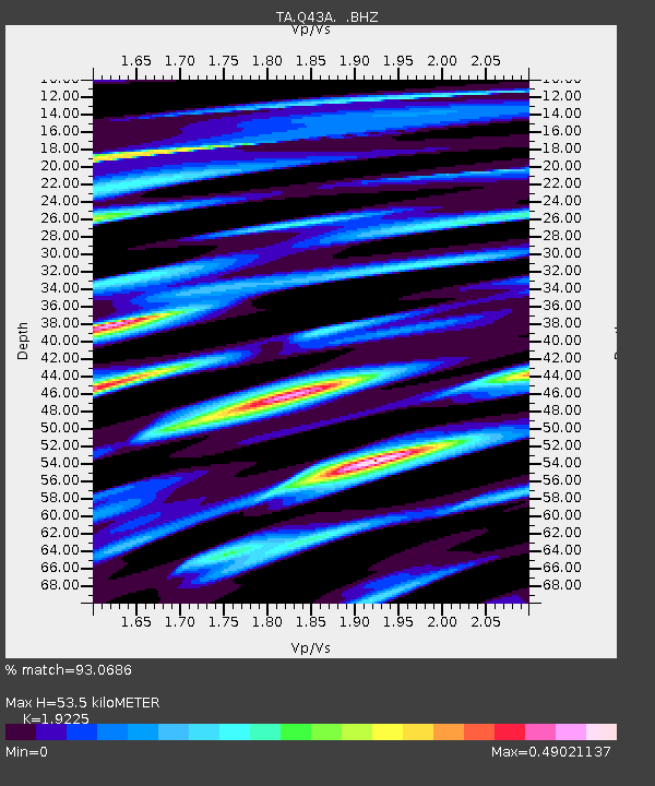
Q43A New Douglas, IL, USA - Earthquake Result Viewer

Earthquake location: Near East Coast Of Honshu, Japan
Earthquake latitude/longitude: 36.9/141.0
Earthquake time(UTC): 2011/07/30 (211) 18:53:49 GMT
Earthquake Depth: 30 km
Earthquake Magnitude: 6.4 MB, 6.0 MS, 6.5 MW, 6.4 MW
Earthquake Catalog/Contributor: WHDF/NEIC
Network: TA USArray Transportable Network (new EarthScope stations)
Station: Q43A New Douglas, IL, USA
Lat/Lon: 38.94 N/89.70 W
Elevation: 202 m
Distance: 91.2 deg
Az: 37.104 deg
Baz: 321.702 deg
Ray Param: 0.0416134
Estimated Moho Depth: 53.5 km
Estimated Crust Vp/Vs: 1.92
Assumed Crust Vp: 6.444 km/s
Estimated Crust Vs: 3.352 km/s
Estimated Crust Poisson's Ratio: 0.31
Radial Match: 93.0686 %
Radial Bump: 356
Transverse Match: 85.01794 %
Transverse Bump: 400
SOD ConfigId: 408116
Insert Time: 2012-01-01 01:40:29.194 +0000
GWidth: 2.5
Max Bumps: 400
Tol: 0.001

Signal To Noise

ChannelStoNSTALTA
TA:Q43A: :BHZ:20110730T19:06:20.57502Z34.640053.216615E-69.2858265E-8
TA:Q43A: :BHN:20110730T19:06:20.57502Z7.35235747.6124525E-71.0353757E-7
TA:Q43A: :BHE:20110730T19:06:20.57502Z5.79918247.88401E-71.3595037E-7
Arrivals
Ps7.8 SECOND
PpPs24 SECOND
PsPs/PpSs32 SECOND