You are here: Home > Network List > TA - USArray Transportable Network (new EarthScope stations) Stations List
> Station Q44A Meyer Farm, Vandalia, IL, USA > Earthquake Result Viewer
Q44A Meyer Farm, Vandalia, IL, USA - Earthquake Result Viewer
| Earthquake location: |
Near East Coast Of Honshu, Japan |
| Earthquake latitude/longitude: |
36.9/141.0 |
| Earthquake time(UTC): |
2011/07/30 (211) 18:53:49 GMT |
| Earthquake Depth: |
30 km |
| Earthquake Magnitude: |
6.4 MB, 6.0 MS, 6.5 MW, 6.4 MW |
| Earthquake Catalog/Contributor: |
WHDF/NEIC |
|
| Network: |
TA USArray Transportable Network (new EarthScope stations) |
| Station: |
Q44A Meyer Farm, Vandalia, IL, USA |
| Lat/Lon: |
38.90 N/89.02 W |
| Elevation: |
164 m |
|
| Distance: |
91.6 deg |
| Az: |
36.708 deg |
| Baz: |
322.139 deg |
| Ray Param: |
0.041579634 |
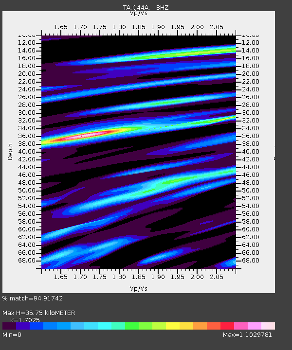
| Estimated Moho Depth: |
35.75 km |
| Estimated Crust Vp/Vs: |
1.70 |
| Assumed Crust Vp: |
6.444 km/s |
| Estimated Crust Vs: |
3.785 km/s |
| Estimated Crust Poisson's Ratio: |
0.24 |
|
| Radial Match: |
94.91742 % |
| Radial Bump: |
317 |
| Transverse Match: |
84.84312 % |
| Transverse Bump: |
400 |
| SOD ConfigId: |
408116 |
| Insert Time: |
2012-01-01 01:40:31.548 +0000 |
| GWidth: |
2.5 |
| Max Bumps: |
400 |
| Tol: |
0.001 |
|
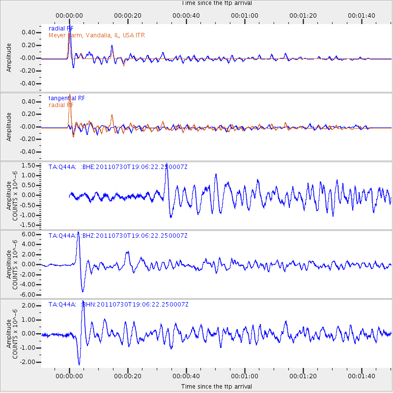
Signal To Noise
| Channel | StoN | STA | LTA |
| TA:Q44A: :BHZ:20110730T19:06:22.250007Z | 40.454956 | 3.0915337E-6 | 7.6419155E-8 |
| TA:Q44A: :BHN:20110730T19:06:22.250007Z | 11.8414345 | 1.0751662E-6 | 9.079695E-8 |
| TA:Q44A: :BHE:20110730T19:06:22.250007Z | 6.5234585 | 6.6511126E-7 | 1.0195684E-7 |
| Arrivals |
| Ps | 4.0 SECOND |
| PpPs | 15 SECOND |
| PsPs/PpSs | 19 SECOND |


