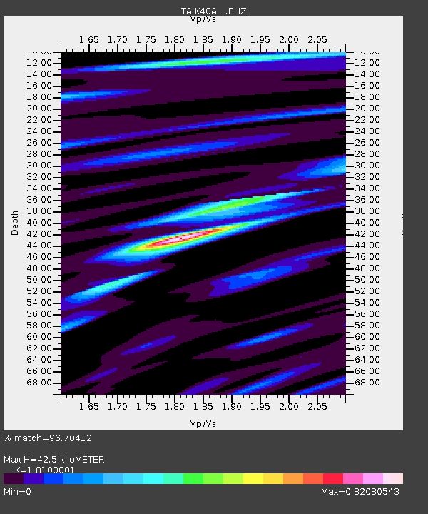
K40A Colesburg, IA, USA - Earthquake Result Viewer

Earthquake location: Near East Coast Of Honshu, Japan
Earthquake latitude/longitude: 36.9/141.0
Earthquake time(UTC): 2011/07/30 (211) 18:53:49 GMT
Earthquake Depth: 30 km
Earthquake Magnitude: 6.4 MB, 6.0 MS, 6.5 MW, 6.4 MW
Earthquake Catalog/Contributor: WHDF/NEIC
Network: TA USArray Transportable Network (new EarthScope stations)
Station: K40A Colesburg, IA, USA
Lat/Lon: 42.70 N/91.14 W
Elevation: 274 m
Distance: 87.6 deg
Az: 35.604 deg
Baz: 320.75 deg
Ray Param: 0.043158222
Estimated Moho Depth: 42.5 km
Estimated Crust Vp/Vs: 1.81
Assumed Crust Vp: 6.53 km/s
Estimated Crust Vs: 3.608 km/s
Estimated Crust Poisson's Ratio: 0.28
Radial Match: 96.70412 %
Radial Bump: 400
Transverse Match: 89.29225 %
Transverse Bump: 400
SOD ConfigId: 408116
Insert Time: 2012-01-01 01:40:44.939 +0000
GWidth: 2.5
Max Bumps: 400
Tol: 0.001

Signal To Noise

ChannelStoNSTALTA
TA:K40A: :BHZ:20110730T19:06:03.70002Z72.901225.6488793E-67.748675E-8
TA:K40A: :BHN:20110730T19:06:03.70002Z18.2189031.6849642E-69.24844E-8
TA:K40A: :BHE:20110730T19:06:03.70002Z23.2911321.4317209E-66.1470644E-8
Arrivals
Ps5.4 SECOND
PpPs18 SECOND
PsPs/PpSs23 SECOND