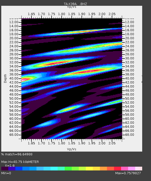
K39A Oelwein, IA, USA - Earthquake Result Viewer
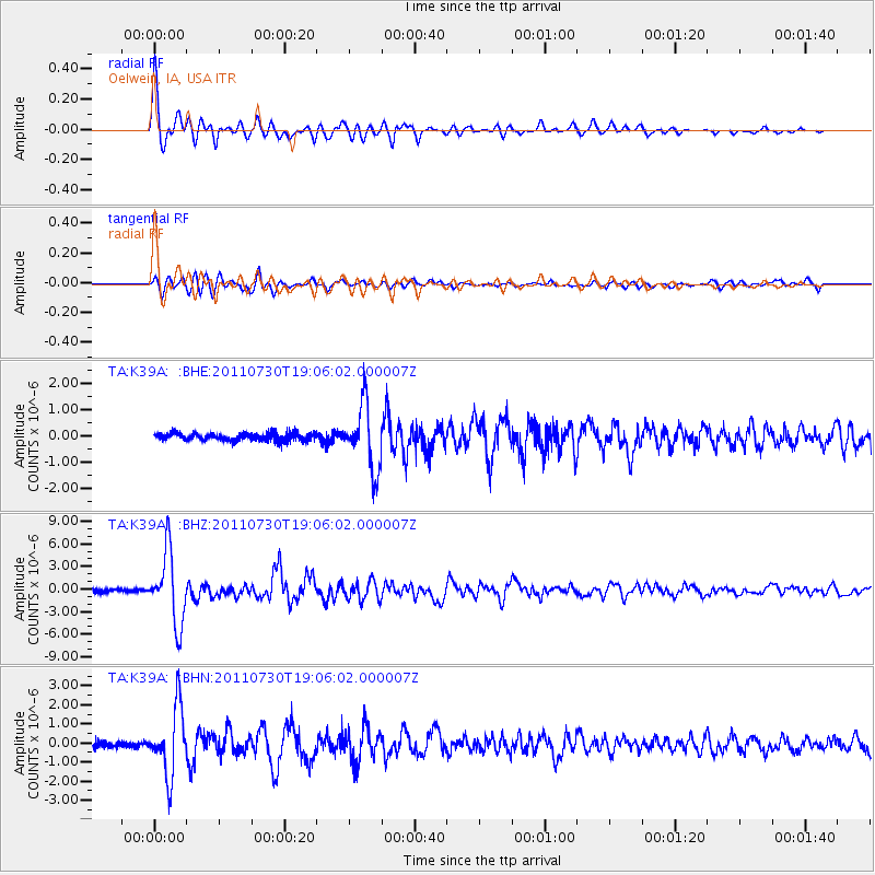
Earthquake location: Near East Coast Of Honshu, Japan
Earthquake latitude/longitude: 36.9/141.0
Earthquake time(UTC): 2011/07/30 (211) 18:53:49 GMT
Earthquake Depth: 30 km
Earthquake Magnitude: 6.4 MB, 6.0 MS, 6.5 MW, 6.4 MW
Earthquake Catalog/Contributor: WHDF/NEIC
Network: TA USArray Transportable Network (new EarthScope stations)
Station: K39A Oelwein, IA, USA
Lat/Lon: 42.71 N/91.89 W
Elevation: 332 m
Distance: 87.3 deg
Az: 36.027 deg
Baz: 320.262 deg
Ray Param: 0.043411136
Estimated Moho Depth: 40.75 km
Estimated Crust Vp/Vs: 1.60
Assumed Crust Vp: 6.53 km/s
Estimated Crust Vs: 4.082 km/s
Estimated Crust Poisson's Ratio: 0.18
Radial Match: 96.64988 %
Radial Bump: 400
Transverse Match: 86.82323 %
Transverse Bump: 400
SOD ConfigId: 408116
Insert Time: 2012-01-01 01:40:55.638 +0000
GWidth: 2.5
Max Bumps: 400
Tol: 0.001

Signal To Noise

ChannelStoNSTALTA
TA:K39A: :BHZ:20110730T19:06:02.000007Z35.4941024.7068374E-61.32609E-7
TA:K39A: :BHN:20110730T19:06:02.000007Z12.6436411.7211744E-61.3612963E-7
TA:K39A: :BHE:20110730T19:06:02.000007Z8.8362221.2468031E-61.411014E-7
Arrivals
Ps3.8 SECOND
PpPs16 SECOND
PsPs/PpSs20 SECOND