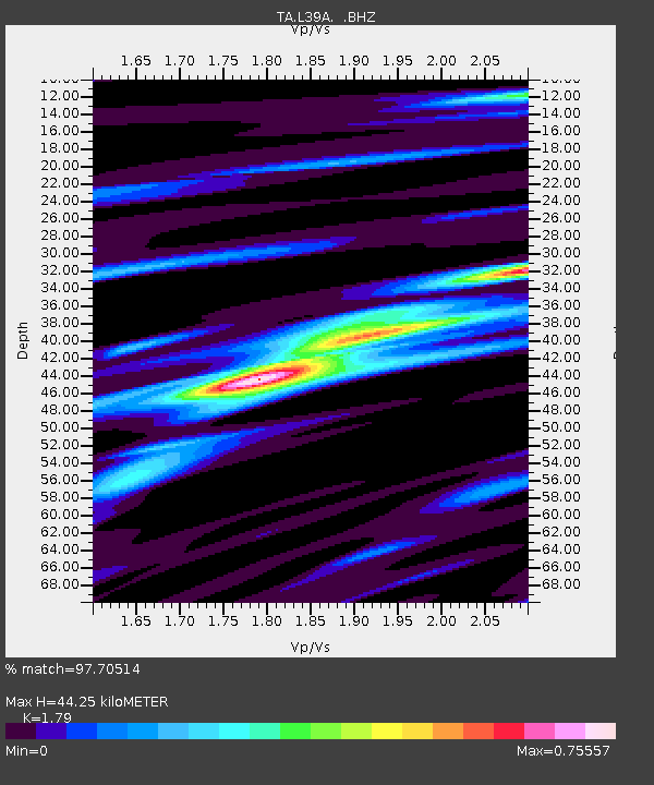
L39A Vinton, IA, USA - Earthquake Result Viewer
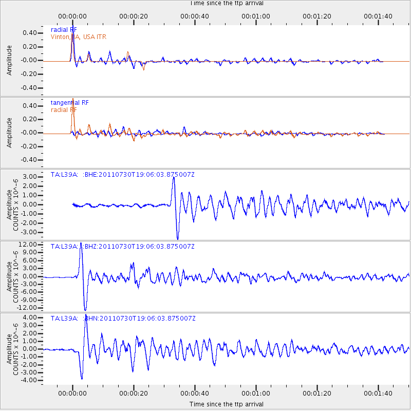
Earthquake location: Near East Coast Of Honshu, Japan
Earthquake latitude/longitude: 36.9/141.0
Earthquake time(UTC): 2011/07/30 (211) 18:53:49 GMT
Earthquake Depth: 30 km
Earthquake Magnitude: 6.4 MB, 6.0 MS, 6.5 MW, 6.4 MW
Earthquake Catalog/Contributor: WHDF/NEIC
Network: TA USArray Transportable Network (new EarthScope stations)
Station: L39A Vinton, IA, USA
Lat/Lon: 42.12 N/92.00 W
Elevation: 261 m
Distance: 87.7 deg
Az: 36.464 deg
Baz: 320.205 deg
Ray Param: 0.04313002
Estimated Moho Depth: 44.25 km
Estimated Crust Vp/Vs: 1.79
Assumed Crust Vp: 6.53 km/s
Estimated Crust Vs: 3.648 km/s
Estimated Crust Poisson's Ratio: 0.27
Radial Match: 97.70514 %
Radial Bump: 314
Transverse Match: 90.57342 %
Transverse Bump: 400
SOD ConfigId: 408116
Insert Time: 2012-01-01 01:41:07.539 +0000
GWidth: 2.5
Max Bumps: 400
Tol: 0.001

Signal To Noise

ChannelStoNSTALTA
TA:L39A: :BHZ:20110730T19:06:03.875007Z42.7046056.762864E-61.5836382E-7
TA:L39A: :BHN:20110730T19:06:03.875007Z15.2304582.0220543E-61.3276386E-7
TA:L39A: :BHE:20110730T19:06:03.875007Z16.6099471.6744276E-61.0080873E-7
Arrivals
Ps5.5 SECOND
PpPs18 SECOND
PsPs/PpSs24 SECOND