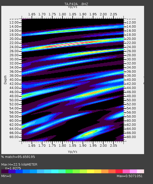
P42A Winchester, IL, USA - Earthquake Result Viewer

Earthquake location: Near East Coast Of Honshu, Japan
Earthquake latitude/longitude: 36.9/141.0
Earthquake time(UTC): 2011/07/30 (211) 18:53:49 GMT
Earthquake Depth: 30 km
Earthquake Magnitude: 6.4 MB, 6.0 MS, 6.5 MW, 6.4 MW
Earthquake Catalog/Contributor: WHDF/NEIC
Network: TA USArray Transportable Network (new EarthScope stations)
Station: P42A Winchester, IL, USA
Lat/Lon: 39.59 N/90.34 W
Elevation: 197 m
Distance: 90.4 deg
Az: 37.095 deg
Baz: 321.296 deg
Ray Param: 0.041671548
Estimated Moho Depth: 22.5 km
Estimated Crust Vp/Vs: 1.83
Assumed Crust Vp: 6.498 km/s
Estimated Crust Vs: 3.555 km/s
Estimated Crust Poisson's Ratio: 0.29
Radial Match: 95.659195 %
Radial Bump: 274
Transverse Match: 87.30609 %
Transverse Bump: 400
SOD ConfigId: 408116
Insert Time: 2012-01-01 01:41:32.409 +0000
GWidth: 2.5
Max Bumps: 400
Tol: 0.001

Signal To Noise

ChannelStoNSTALTA
TA:P42A: :BHZ:20110730T19:06:16.82502Z36.1759223.894875E-61.0766485E-7
TA:P42A: :BHN:20110730T19:06:16.82502Z15.0673391.3894921E-69.221882E-8
TA:P42A: :BHE:20110730T19:06:16.82502Z9.6347779.839314E-71.021229E-7
Arrivals
Ps2.9 SECOND
PpPs9.6 SECOND
PsPs/PpSs13 SECOND