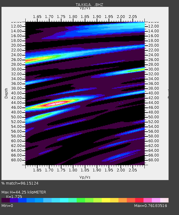
K41A Shullsburg, WI, USA - Earthquake Result Viewer

Earthquake location: Near East Coast Of Honshu, Japan
Earthquake latitude/longitude: 36.9/141.0
Earthquake time(UTC): 2011/07/30 (211) 18:53:49 GMT
Earthquake Depth: 30 km
Earthquake Magnitude: 6.4 MB, 6.0 MS, 6.5 MW, 6.4 MW
Earthquake Catalog/Contributor: WHDF/NEIC
Network: TA USArray Transportable Network (new EarthScope stations)
Station: K41A Shullsburg, WI, USA
Lat/Lon: 42.61 N/90.30 W
Elevation: 298 m
Distance: 88.1 deg
Az: 35.184 deg
Baz: 321.297 deg
Ray Param: 0.04281736
Estimated Moho Depth: 44.25 km
Estimated Crust Vp/Vs: 1.73
Assumed Crust Vp: 6.53 km/s
Estimated Crust Vs: 3.786 km/s
Estimated Crust Poisson's Ratio: 0.25
Radial Match: 96.15124 %
Radial Bump: 400
Transverse Match: 92.357796 %
Transverse Bump: 400
SOD ConfigId: 408116
Insert Time: 2012-01-01 01:41:45.070 +0000
GWidth: 2.5
Max Bumps: 400
Tol: 0.001

Signal To Noise

ChannelStoNSTALTA
TA:K41A: :BHZ:20110730T19:06:05.899971Z38.611435.0034373E-61.2958435E-7
TA:K41A: :BHN:20110730T19:06:05.899971Z14.5552271.4535115E-69.986182E-8
TA:K41A: :BHE:20110730T19:06:05.899971Z12.0855121.5170747E-61.2552837E-7
Arrivals
Ps5.0 SECOND
PpPs18 SECOND
PsPs/PpSs23 SECOND