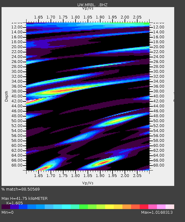
MRBL Marblemount, WA, USA - Earthquake Result Viewer
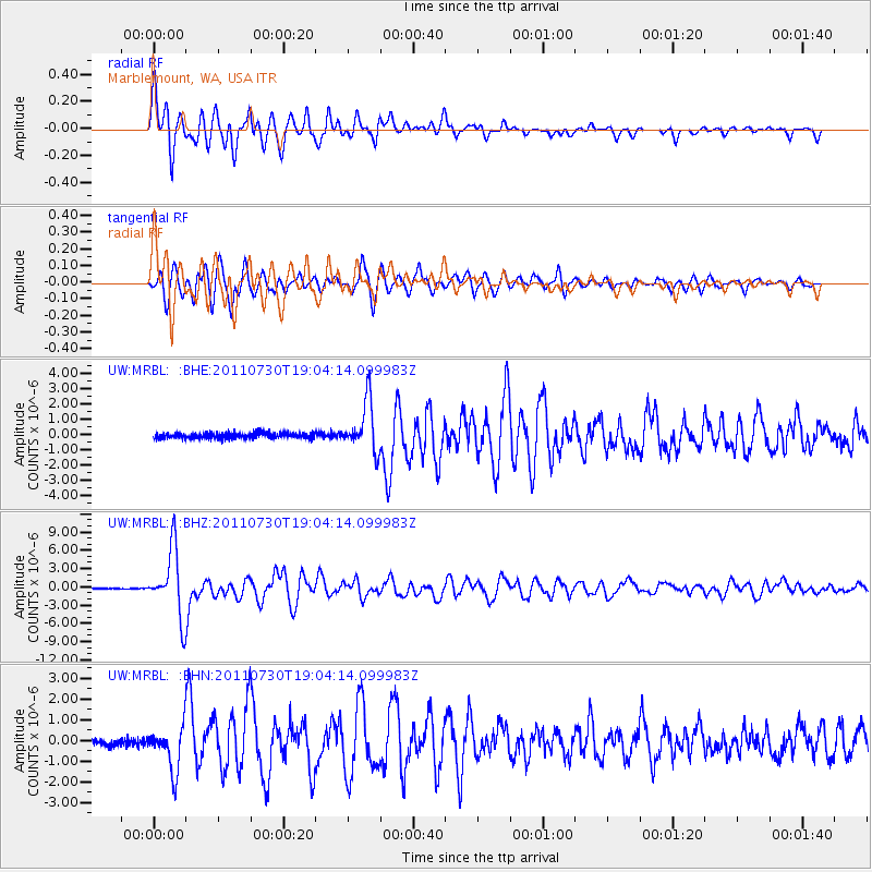
Earthquake location: Near East Coast Of Honshu, Japan
Earthquake latitude/longitude: 36.9/141.0
Earthquake time(UTC): 2011/07/30 (211) 18:53:49 GMT
Earthquake Depth: 30 km
Earthquake Magnitude: 6.4 MB, 6.0 MS, 6.5 MW, 6.4 MW
Earthquake Catalog/Contributor: WHDF/NEIC
Network: UW Pacific Northwest Regional Seismic Network
Station: MRBL Marblemount, WA, USA
Lat/Lon: 48.52 N/121.48 W
Elevation: 75 m
Distance: 67.9 deg
Az: 45.365 deg
Baz: 300.967 deg
Ray Param: 0.056641005
Estimated Moho Depth: 41.75 km
Estimated Crust Vp/Vs: 1.61
Assumed Crust Vp: 6.566 km/s
Estimated Crust Vs: 4.091 km/s
Estimated Crust Poisson's Ratio: 0.18
Radial Match: 88.50569 %
Radial Bump: 400
Transverse Match: 91.165474 %
Transverse Bump: 400
SOD ConfigId: 408116
Insert Time: 2012-01-01 01:43:19.116 +0000
GWidth: 2.5
Max Bumps: 400
Tol: 0.001

Signal To Noise

ChannelStoNSTALTA
UW:MRBL: :BHZ:20110730T19:04:14.099983Z62.1263245.409334E-68.7069914E-8
UW:MRBL: :BHN:20110730T19:04:14.099983Z7.0527491.0513002E-61.4906246E-7
UW:MRBL: :BHE:20110730T19:04:14.099983Z9.4159241.6360411E-61.7375258E-7
Arrivals
Ps4.0 SECOND
PpPs16 SECOND
PsPs/PpSs20 SECOND