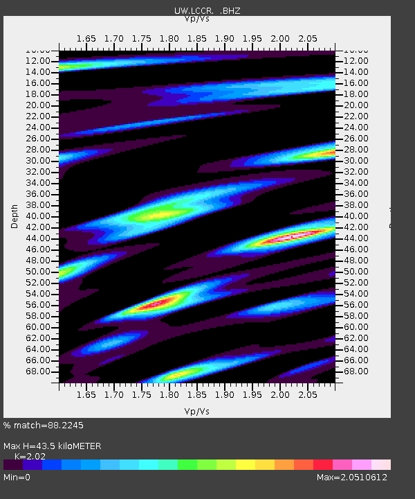
LCCR Mulino, OR, USA - Earthquake Result Viewer

Earthquake location: Near East Coast Of Honshu, Japan
Earthquake latitude/longitude: 36.9/141.0
Earthquake time(UTC): 2011/07/30 (211) 18:53:49 GMT
Earthquake Depth: 30 km
Earthquake Magnitude: 6.4 MB, 6.0 MS, 6.5 MW, 6.4 MW
Earthquake Catalog/Contributor: WHDF/NEIC
Network: UW Pacific Northwest Regional Seismic Network
Station: LCCR Mulino, OR, USA
Lat/Lon: 45.21 N/122.48 W
Elevation: 273 m
Distance: 69.0 deg
Az: 48.792 deg
Baz: 301.504 deg
Ray Param: 0.05589927
Estimated Moho Depth: 43.5 km
Estimated Crust Vp/Vs: 2.02
Assumed Crust Vp: 6.566 km/s
Estimated Crust Vs: 3.251 km/s
Estimated Crust Poisson's Ratio: 0.34
Radial Match: 88.2245 %
Radial Bump: 400
Transverse Match: 82.612305 %
Transverse Bump: 400
SOD ConfigId: 408116
Insert Time: 2012-01-01 01:43:34.163 +0000
GWidth: 2.5
Max Bumps: 400
Tol: 0.001

Signal To Noise

ChannelStoNSTALTA
UW:LCCR: :BHZ:20110730T19:04:21.174995Z28.6506485.705291E-61.9913305E-7
UW:LCCR: :BHN:20110730T19:04:21.174995Z3.44988421.2665892E-63.6713962E-7
UW:LCCR: :BHE:20110730T19:04:21.174995Z5.91164642.038455E-63.4482022E-7
Arrivals
Ps7.0 SECOND
PpPs19 SECOND
PsPs/PpSs26 SECOND