You are here: Home > Network List > CI - Caltech Regional Seismic Network Stations List
> Station DAN Danby, California, USA > Earthquake Result Viewer
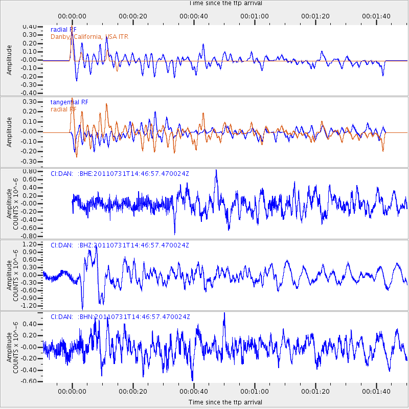
DAN Danby, California, USA - Earthquake Result Viewer
*The percent match for this event was below the threshold and hence no stack was calculated.
| Earthquake location: |
Vanuatu Islands Region |
| Earthquake latitude/longitude: |
-17.0/171.6 |
| Earthquake time(UTC): |
2011/07/31 (212) 14:34:47 GMT |
| Earthquake Depth: |
10 km |
| Earthquake Magnitude: |
5.8 MB, 5.7 MS, 6.2 MW, 6.1 MW |
| Earthquake Catalog/Contributor: |
WHDF/NEIC |
|
| Network: |
CI Caltech Regional Seismic Network |
| Station: |
DAN Danby, California, USA |
| Lat/Lon: |
34.64 N/115.38 W |
| Elevation: |
398 m |
|
| Distance: |
86.2 deg |
| Az: |
52.222 deg |
| Baz: |
246.511 deg |
| Ray Param: |
$rayparam |
*The percent match for this event was below the threshold and hence was not used in the summary stack. |
|
| Radial Match: |
78.25235 % |
| Radial Bump: |
400 |
| Transverse Match: |
57.77361 % |
| Transverse Bump: |
400 |
| SOD ConfigId: |
408116 |
| Insert Time: |
2012-01-01 01:53:44.731 +0000 |
| GWidth: |
2.5 |
| Max Bumps: |
400 |
| Tol: |
0.001 |
|
Signal To Noise
| Channel | StoN | STA | LTA |
| CI:DAN: :BHZ:20110731T14:46:57.470024Z | 4.2365003 | 4.4329937E-7 | 1.0463811E-7 |
| CI:DAN: :BHN:20110731T14:46:57.470024Z | 1.0798885 | 1.2467417E-7 | 1.1545098E-7 |
| CI:DAN: :BHE:20110731T14:46:57.470024Z | 1.7904783 | 2.0453884E-7 | 1.14236975E-7 |
| Arrivals |
| Ps | |
| PpPs | |
| PsPs/PpSs | |


