You are here: Home > Network List > G - GEOSCOPE Stations List
> Station CRZF Port Alfred, Crozet, South Indian Ocean > Earthquake Result Viewer
CRZF Port Alfred, Crozet, South Indian Ocean - Earthquake Result Viewer
| Earthquake location: |
Solomon Islands |
| Earthquake latitude/longitude: |
-10.5/160.8 |
| Earthquake time(UTC): |
2003/01/20 (020) 08:43:06 GMT |
| Earthquake Depth: |
33 km |
| Earthquake Magnitude: |
6.7 MB, 7.8 MS, 7.3 MW, 7.2 MW |
| Earthquake Catalog/Contributor: |
WHDF/NEIC |
|
| Network: |
G GEOSCOPE |
| Station: |
CRZF Port Alfred, Crozet, South Indian Ocean |
| Lat/Lon: |
46.43 S/51.86 E |
| Elevation: |
140 m |
|
| Distance: |
95.2 deg |
| Az: |
221.071 deg |
| Baz: |
110.901 deg |
| Ray Param: |
0.040843833 |
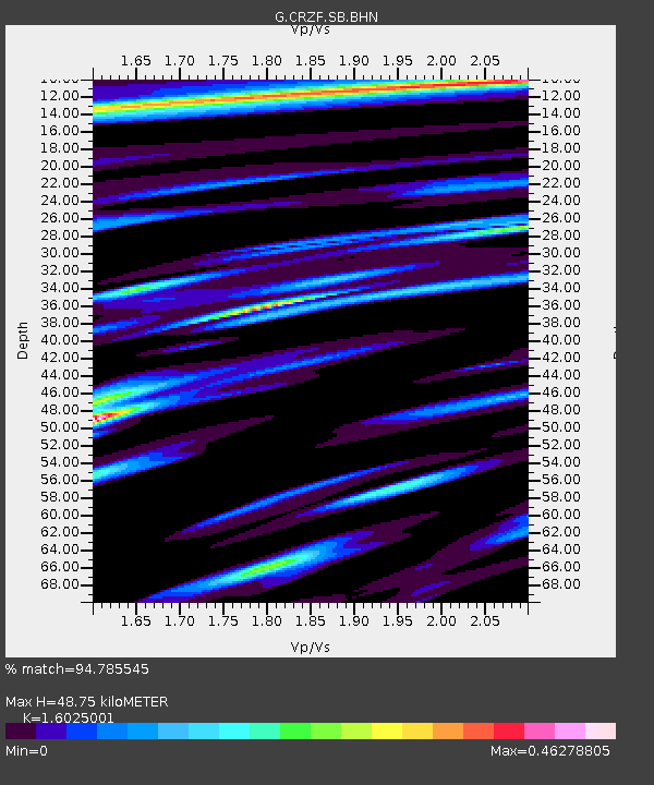
| Estimated Moho Depth: |
48.75 km |
| Estimated Crust Vp/Vs: |
1.60 |
| Assumed Crust Vp: |
4.802 km/s |
| Estimated Crust Vs: |
2.997 km/s |
| Estimated Crust Poisson's Ratio: |
0.18 |
|
| Radial Match: |
94.785545 % |
| Radial Bump: |
400 |
| Transverse Match: |
84.599556 % |
| Transverse Bump: |
400 |
| SOD ConfigId: |
4714 |
| Insert Time: |
2010-02-26 21:54:53.548 +0000 |
| GWidth: |
2.5 |
| Max Bumps: |
400 |
| Tol: |
0.001 |
|
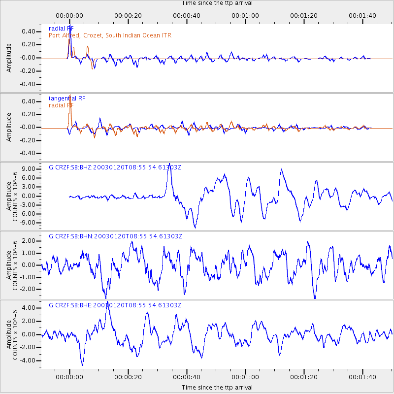
Signal To Noise
| Channel | StoN | STA | LTA |
| G:CRZF:SB:BHN:20030120T08:55:54.61303Z | 1.2359419 | 4.4962295E-7 | 3.6378972E-7 |
| G:CRZF:SB:BHE:20030120T08:55:54.61303Z | 5.5495934 | 1.9754957E-6 | 3.5597128E-7 |
| G:CRZF:SB:BHZ:20030120T08:55:54.61303Z | 13.164737 | 4.8916013E-6 | 3.715685E-7 |
| Arrivals |
| Ps | 6.2 SECOND |
| PpPs | 26 SECOND |
| PsPs/PpSs | 32 SECOND |


