You are here: Home > Network List > TA - USArray Transportable Network (new EarthScope stations) Stations List
> Station R11A Troy Canyon, Currant, NV, USA > Earthquake Result Viewer
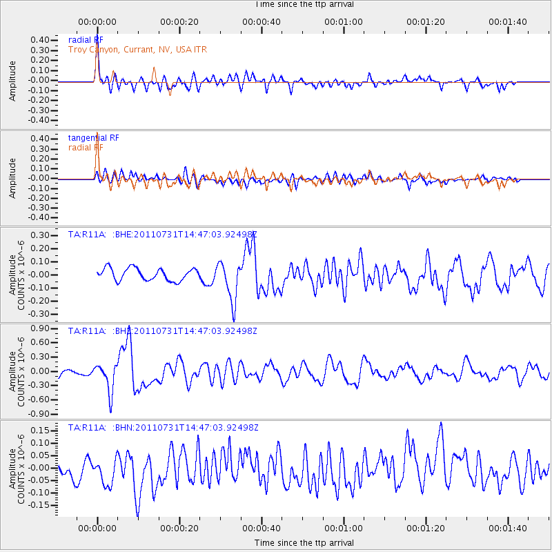
R11A Troy Canyon, Currant, NV, USA - Earthquake Result Viewer
*The percent match for this event was below the threshold and hence no stack was calculated.
| Earthquake location: |
Vanuatu Islands Region |
| Earthquake latitude/longitude: |
-17.0/171.6 |
| Earthquake time(UTC): |
2011/07/31 (212) 14:34:47 GMT |
| Earthquake Depth: |
10 km |
| Earthquake Magnitude: |
5.8 MB, 5.7 MS, 6.2 MW, 6.1 MW |
| Earthquake Catalog/Contributor: |
WHDF/NEIC |
|
| Network: |
TA USArray Transportable Network (new EarthScope stations) |
| Station: |
R11A Troy Canyon, Currant, NV, USA |
| Lat/Lon: |
38.35 N/115.59 W |
| Elevation: |
1756 m |
|
| Distance: |
87.6 deg |
| Az: |
48.757 deg |
| Baz: |
246.202 deg |
| Ray Param: |
$rayparam |
*The percent match for this event was below the threshold and hence was not used in the summary stack. |
|
| Radial Match: |
76.64252 % |
| Radial Bump: |
400 |
| Transverse Match: |
60.03026 % |
| Transverse Bump: |
400 |
| SOD ConfigId: |
408116 |
| Insert Time: |
2012-01-01 02:00:06.052 +0000 |
| GWidth: |
2.5 |
| Max Bumps: |
400 |
| Tol: |
0.001 |
|
Signal To Noise
| Channel | StoN | STA | LTA |
| TA:R11A: :BHZ:20110731T14:47:03.92498Z | 3.745149 | 3.0579352E-7 | 8.165057E-8 |
| TA:R11A: :BHN:20110731T14:47:03.92498Z | 1.4498093 | 6.7187564E-8 | 4.6342343E-8 |
| TA:R11A: :BHE:20110731T14:47:03.92498Z | 3.34746 | 1.5475288E-7 | 4.622994E-8 |
| Arrivals |
| Ps | |
| PpPs | |
| PsPs/PpSs | |


