You are here: Home > Network List > TA - USArray Transportable Network (new EarthScope stations) Stations List
> Station G05D Wamic, OR, USA > Earthquake Result Viewer
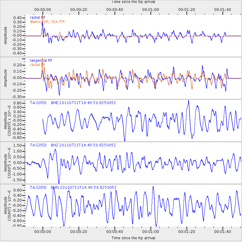
G05D Wamic, OR, USA - Earthquake Result Viewer
*The percent match for this event was below the threshold and hence no stack was calculated.
| Earthquake location: |
Vanuatu Islands Region |
| Earthquake latitude/longitude: |
-17.0/171.6 |
| Earthquake time(UTC): |
2011/07/31 (212) 14:34:47 GMT |
| Earthquake Depth: |
10 km |
| Earthquake Magnitude: |
5.8 MB, 5.7 MS, 6.2 MW, 6.1 MW |
| Earthquake Catalog/Contributor: |
WHDF/NEIC |
|
| Network: |
TA USArray Transportable Network (new EarthScope stations) |
| Station: |
G05D Wamic, OR, USA |
| Lat/Lon: |
45.24 N/121.32 W |
| Elevation: |
592 m |
|
| Distance: |
86.7 deg |
| Az: |
40.685 deg |
| Baz: |
241.986 deg |
| Ray Param: |
$rayparam |
*The percent match for this event was below the threshold and hence was not used in the summary stack. |
|
| Radial Match: |
44.65884 % |
| Radial Bump: |
400 |
| Transverse Match: |
55.229393 % |
| Transverse Bump: |
400 |
| SOD ConfigId: |
408116 |
| Insert Time: |
2012-01-01 02:01:29.847 +0000 |
| GWidth: |
2.5 |
| Max Bumps: |
400 |
| Tol: |
0.001 |
|
Signal To Noise
| Channel | StoN | STA | LTA |
| TA:G05D: :BHZ:20110731T14:46:59.825005Z | 2.646896 | 5.8028104E-7 | 2.1923077E-7 |
| TA:G05D: :BHN:20110731T14:46:59.825005Z | 1.7511358 | 3.6254505E-7 | 2.0703422E-7 |
| TA:G05D: :BHE:20110731T14:46:59.825005Z | 0.7040423 | 1.9480268E-7 | 2.766917E-7 |
| Arrivals |
| Ps | |
| PpPs | |
| PsPs/PpSs | |


