You are here: Home > Network List > TA - USArray Transportable Network (new EarthScope stations) Stations List
> Station L04D Klamath Falls, OR, USA > Earthquake Result Viewer
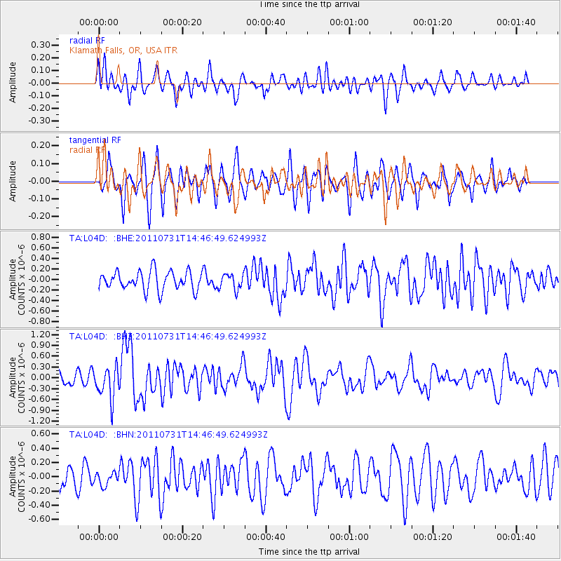
L04D Klamath Falls, OR, USA - Earthquake Result Viewer
*The percent match for this event was below the threshold and hence no stack was calculated.
| Earthquake location: |
Vanuatu Islands Region |
| Earthquake latitude/longitude: |
-17.0/171.6 |
| Earthquake time(UTC): |
2011/07/31 (212) 14:34:47 GMT |
| Earthquake Depth: |
10 km |
| Earthquake Magnitude: |
5.8 MB, 5.7 MS, 6.2 MW, 6.1 MW |
| Earthquake Catalog/Contributor: |
WHDF/NEIC |
|
| Network: |
TA USArray Transportable Network (new EarthScope stations) |
| Station: |
L04D Klamath Falls, OR, USA |
| Lat/Lon: |
42.22 N/122.30 W |
| Elevation: |
1437 m |
|
| Distance: |
84.7 deg |
| Az: |
43.015 deg |
| Baz: |
241.48 deg |
| Ray Param: |
$rayparam |
*The percent match for this event was below the threshold and hence was not used in the summary stack. |
|
| Radial Match: |
67.4771 % |
| Radial Bump: |
400 |
| Transverse Match: |
62.232044 % |
| Transverse Bump: |
400 |
| SOD ConfigId: |
408116 |
| Insert Time: |
2012-01-01 02:02:20.730 +0000 |
| GWidth: |
2.5 |
| Max Bumps: |
400 |
| Tol: |
0.001 |
|
Signal To Noise
| Channel | StoN | STA | LTA |
| TA:L04D: :BHZ:20110731T14:46:49.624993Z | 2.8131142 | 4.469037E-7 | 1.5886441E-7 |
| TA:L04D: :BHN:20110731T14:46:49.624993Z | 0.41455352 | 9.3754444E-8 | 2.2615764E-7 |
| TA:L04D: :BHE:20110731T14:46:49.624993Z | 0.82648504 | 1.4579764E-7 | 1.7640689E-7 |
| Arrivals |
| Ps | |
| PpPs | |
| PsPs/PpSs | |


