You are here: Home > Network List > G - GEOSCOPE Stations List
> Station CRZF Port Alfred, Crozet, South Indian Ocean > Earthquake Result Viewer
CRZF Port Alfred, Crozet, South Indian Ocean - Earthquake Result Viewer
| Earthquake location: |
Southern Sumatra, Indonesia |
| Earthquake latitude/longitude: |
-0.5/99.3 |
| Earthquake time(UTC): |
1998/04/01 (091) 17:56:23 GMT |
| Earthquake Depth: |
56 km |
| Earthquake Magnitude: |
6.2 MB, 6.9 MS, 7.0 UNKNOWN, 6.6 ME |
| Earthquake Catalog/Contributor: |
WHDF/NEIC |
|
| Network: |
G GEOSCOPE |
| Station: |
CRZF Port Alfred, Crozet, South Indian Ocean |
| Lat/Lon: |
46.43 S/51.86 E |
| Elevation: |
140 m |
|
| Distance: |
61.6 deg |
| Az: |
215.349 deg |
| Baz: |
56.765 deg |
| Ray Param: |
0.060616784 |
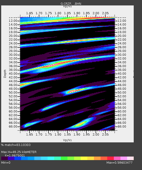
| Estimated Moho Depth: |
49.25 km |
| Estimated Crust Vp/Vs: |
1.87 |
| Assumed Crust Vp: |
4.802 km/s |
| Estimated Crust Vs: |
2.571 km/s |
| Estimated Crust Poisson's Ratio: |
0.30 |
|
| Radial Match: |
83.10303 % |
| Radial Bump: |
382 |
| Transverse Match: |
62.827885 % |
| Transverse Bump: |
400 |
| SOD ConfigId: |
4480 |
| Insert Time: |
2010-02-26 21:54:54.979 +0000 |
| GWidth: |
2.5 |
| Max Bumps: |
400 |
| Tol: |
0.001 |
|

Signal To Noise
| Channel | StoN | STA | LTA |
| G:CRZF: :BHN:19980401T18:06:04.568005Z | 2.3910346 | 1.6635418E-6 | 6.9574145E-7 |
| G:CRZF: :BHE:19980401T18:06:04.568005Z | 1.5060266 | 7.969961E-7 | 5.292045E-7 |
| G:CRZF: :BHZ:19980401T18:06:04.568005Z | 1.0768238 | 6.944193E-7 | 6.448774E-7 |
| Arrivals |
| Ps | 9.1 SECOND |
| PpPs | 29 SECOND |
| PsPs/PpSs | 38 SECOND |


