You are here: Home > Network List > UW - Pacific Northwest Regional Seismic Network Stations List
> Station WOLL Wollman Farm, Schrag, WA, USA > Earthquake Result Viewer
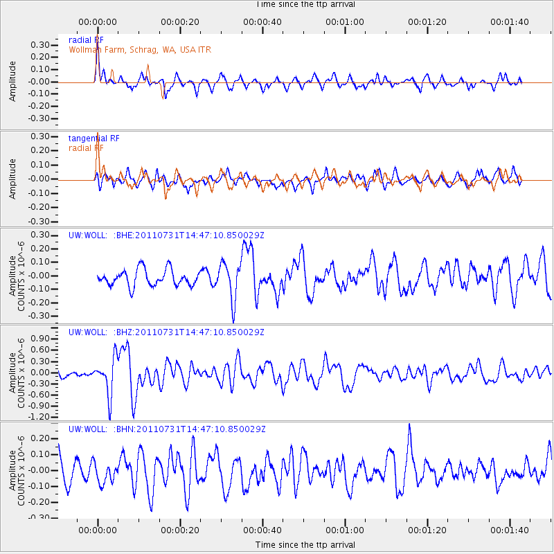
WOLL Wollman Farm, Schrag, WA, USA - Earthquake Result Viewer
*The percent match for this event was below the threshold and hence no stack was calculated.
| Earthquake location: |
Vanuatu Islands Region |
| Earthquake latitude/longitude: |
-17.0/171.6 |
| Earthquake time(UTC): |
2011/07/31 (212) 14:34:47 GMT |
| Earthquake Depth: |
10 km |
| Earthquake Magnitude: |
5.8 MB, 5.7 MS, 6.2 MW, 6.1 MW |
| Earthquake Catalog/Contributor: |
WHDF/NEIC |
|
| Network: |
UW Pacific Northwest Regional Seismic Network |
| Station: |
WOLL Wollman Farm, Schrag, WA, USA |
| Lat/Lon: |
47.06 N/118.92 W |
| Elevation: |
385 m |
|
| Distance: |
89.0 deg |
| Az: |
39.83 deg |
| Baz: |
243.677 deg |
| Ray Param: |
$rayparam |
*The percent match for this event was below the threshold and hence was not used in the summary stack. |
|
| Radial Match: |
78.447205 % |
| Radial Bump: |
400 |
| Transverse Match: |
56.432156 % |
| Transverse Bump: |
400 |
| SOD ConfigId: |
408116 |
| Insert Time: |
2012-01-01 02:05:05.582 +0000 |
| GWidth: |
2.5 |
| Max Bumps: |
400 |
| Tol: |
0.001 |
|
Signal To Noise
| Channel | StoN | STA | LTA |
| UW:WOLL: :BHZ:20110731T14:47:10.850029Z | 4.186583 | 5.002431E-7 | 1.1948721E-7 |
| UW:WOLL: :BHN:20110731T14:47:10.850029Z | 0.6289051 | 5.9306256E-8 | 9.4300795E-8 |
| UW:WOLL: :BHE:20110731T14:47:10.850029Z | 2.296953 | 1.3725901E-7 | 5.975699E-8 |
| Arrivals |
| Ps | |
| PpPs | |
| PsPs/PpSs | |


