You are here: Home > Network List > G - GEOSCOPE Stations List
> Station CRZF Port Alfred, Crozet, South Indian Ocean > Earthquake Result Viewer
CRZF Port Alfred, Crozet, South Indian Ocean - Earthquake Result Viewer
| Earthquake location: |
Minahassa Peninsula, Sulawesi |
| Earthquake latitude/longitude: |
0.7/120.0 |
| Earthquake time(UTC): |
1996/01/01 (001) 08:05:11 GMT |
| Earthquake Depth: |
33 km |
| Earthquake Magnitude: |
6.2 MB, 7.7 MS, 7.8 UNKNOWN, 7.8 MW |
| Earthquake Catalog/Contributor: |
WHDF/NEIC |
|
| Network: |
G GEOSCOPE |
| Station: |
CRZF Port Alfred, Crozet, South Indian Ocean |
| Lat/Lon: |
46.43 S/51.86 E |
| Elevation: |
140 m |
|
| Distance: |
75.6 deg |
| Az: |
221.503 deg |
| Baz: |
73.333 deg |
| Ray Param: |
0.05151158 |
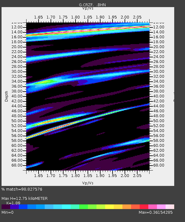
| Estimated Moho Depth: |
12.75 km |
| Estimated Crust Vp/Vs: |
1.89 |
| Assumed Crust Vp: |
4.802 km/s |
| Estimated Crust Vs: |
2.541 km/s |
| Estimated Crust Poisson's Ratio: |
0.31 |
|
| Radial Match: |
98.827576 % |
| Radial Bump: |
272 |
| Transverse Match: |
88.02777 % |
| Transverse Bump: |
400 |
| SOD ConfigId: |
6273 |
| Insert Time: |
2010-02-26 21:55:02.867 +0000 |
| GWidth: |
2.5 |
| Max Bumps: |
400 |
| Tol: |
0.001 |
|
Signal To Noise
| Channel | StoN | STA | LTA |
| G:CRZF: :BHN:19960101T08:16:22.449011Z | 2.4128609 | 1.0877417E-6 | 4.5080992E-7 |
| G:CRZF: :BHE:19960101T08:16:22.449011Z | 6.943066 | 3.3704348E-6 | 4.85439E-7 |
| G:CRZF: :BHZ:19960101T08:16:22.449011Z | 13.815493 | 6.708542E-6 | 4.855811E-7 |
| Arrivals |
| Ps | 2.4 SECOND |
| PpPs | 7.5 SECOND |
| PsPs/PpSs | 10.0 SECOND |


