You are here: Home > Network List > G - GEOSCOPE Stations List
> Station CRZF Port Alfred, Crozet, South Indian Ocean > Earthquake Result Viewer
CRZF Port Alfred, Crozet, South Indian Ocean - Earthquake Result Viewer
| Earthquake location: |
Irian Jaya Region, Indonesia |
| Earthquake latitude/longitude: |
-0.9/137.0 |
| Earthquake time(UTC): |
1996/02/17 (048) 05:59:29 GMT |
| Earthquake Depth: |
33 km |
| Earthquake Magnitude: |
6.5 MB, 8.1 MS, 7.9 UNKNOWN |
| Earthquake Catalog/Contributor: |
WHDF/NEIC |
|
| Network: |
G GEOSCOPE |
| Station: |
CRZF Port Alfred, Crozet, South Indian Ocean |
| Lat/Lon: |
46.43 S/51.86 E |
| Elevation: |
140 m |
|
| Distance: |
86.0 deg |
| Az: |
223.702 deg |
| Baz: |
87.158 deg |
| Ray Param: |
0.044337478 |
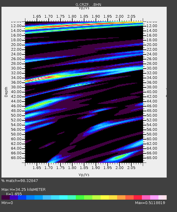
| Estimated Moho Depth: |
34.25 km |
| Estimated Crust Vp/Vs: |
1.65 |
| Assumed Crust Vp: |
4.802 km/s |
| Estimated Crust Vs: |
2.901 km/s |
| Estimated Crust Poisson's Ratio: |
0.21 |
|
| Radial Match: |
98.32847 % |
| Radial Bump: |
295 |
| Transverse Match: |
90.6763 % |
| Transverse Bump: |
400 |
| SOD ConfigId: |
6273 |
| Insert Time: |
2010-02-26 21:55:04.945 +0000 |
| GWidth: |
2.5 |
| Max Bumps: |
400 |
| Tol: |
0.001 |
|
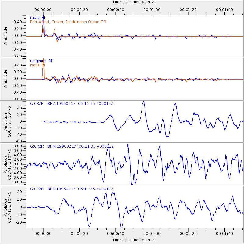
Signal To Noise
| Channel | StoN | STA | LTA |
| G:CRZF: :BHN:19960217T06:11:35.400012Z | 1.5829605 | 8.788506E-7 | 5.551943E-7 |
| G:CRZF: :BHE:19960217T06:11:35.400012Z | 1.8285167 | 1.1397929E-6 | 6.233429E-7 |
| G:CRZF: :BHZ:19960217T06:11:35.400012Z | 2.7238085 | 1.8620482E-6 | 6.836193E-7 |
| Arrivals |
| Ps | 4.7 SECOND |
| PpPs | 19 SECOND |
| PsPs/PpSs | 23 SECOND |


