You are here: Home > Network List > G - GEOSCOPE Stations List
> Station CRZF Port Alfred, Crozet, South Indian Ocean > Earthquake Result Viewer
CRZF Port Alfred, Crozet, South Indian Ocean - Earthquake Result Viewer
| Earthquake location: |
Irian Jaya Region, Indonesia |
| Earthquake latitude/longitude: |
-0.6/135.9 |
| Earthquake time(UTC): |
1996/02/17 (048) 14:21:23 GMT |
| Earthquake Depth: |
33 km |
| Earthquake Magnitude: |
5.8 MB, 6.7 MS, 6.7 UNKNOWN, 6.4 MW |
| Earthquake Catalog/Contributor: |
WHDF/NEIC |
|
| Network: |
G GEOSCOPE |
| Station: |
CRZF Port Alfred, Crozet, South Indian Ocean |
| Lat/Lon: |
46.43 S/51.86 E |
| Elevation: |
140 m |
|
| Distance: |
85.4 deg |
| Az: |
223.636 deg |
| Baz: |
86.075 deg |
| Ray Param: |
0.044721227 |
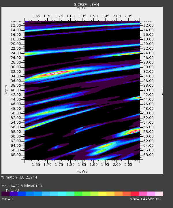
| Estimated Moho Depth: |
32.5 km |
| Estimated Crust Vp/Vs: |
1.73 |
| Assumed Crust Vp: |
4.802 km/s |
| Estimated Crust Vs: |
2.776 km/s |
| Estimated Crust Poisson's Ratio: |
0.25 |
|
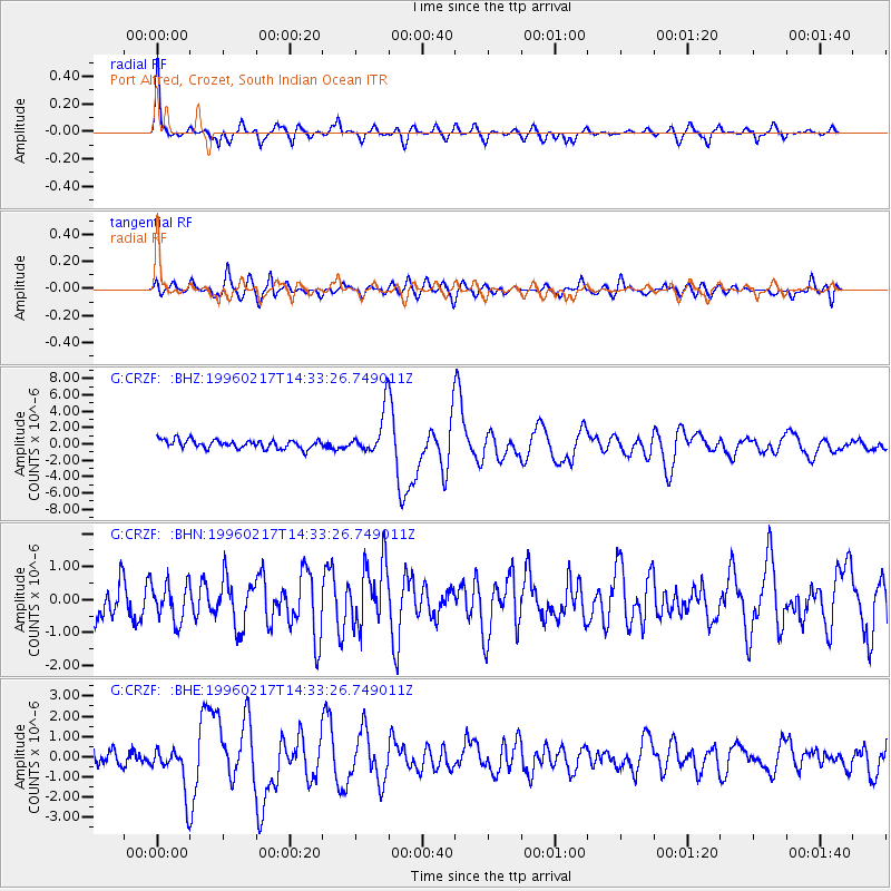
| Radial Match: |
88.21244 % |
| Radial Bump: |
361 |
| Transverse Match: |
66.65062 % |
| Transverse Bump: |
400 |
| SOD ConfigId: |
6273 |
| Insert Time: |
2010-02-26 21:55:07.313 +0000 |
| GWidth: |
2.5 |
| Max Bumps: |
400 |
| Tol: |
0.001 |
|
Signal To Noise
| Channel | StoN | STA | LTA |
| G:CRZF: :BHN:19960217T14:33:26.749011Z | 0.7931639 | 5.6994725E-7 | 7.185744E-7 |
| G:CRZF: :BHE:19960217T14:33:26.749011Z | 2.5481904 | 1.1712805E-6 | 4.5965186E-7 |
| G:CRZF: :BHZ:19960217T14:33:26.749011Z | 4.9248266 | 2.5997188E-6 | 5.278803E-7 |
| Arrivals |
| Ps | 5.0 SECOND |
| PpPs | 18 SECOND |
| PsPs/PpSs | 23 SECOND |


