You are here: Home > Network List > G - GEOSCOPE Stations List
> Station INU Inuyama, Japan > Earthquake Result Viewer
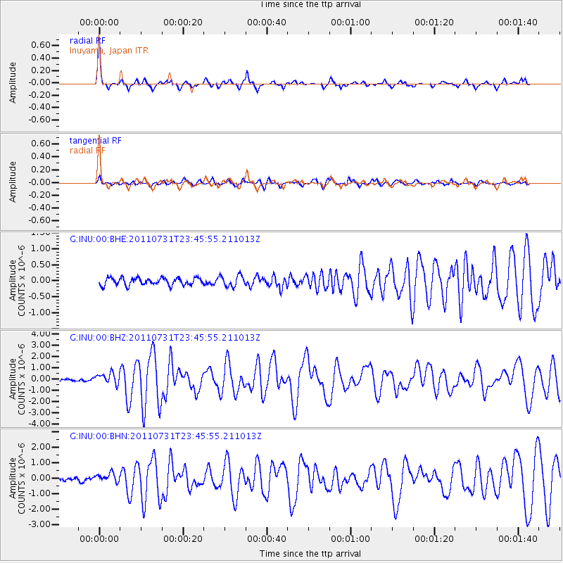
INU Inuyama, Japan - Earthquake Result Viewer
*The percent match for this event was below the threshold and hence no stack was calculated.
| Earthquake location: |
Near N Coast Of New Guinea, P.N.G. |
| Earthquake latitude/longitude: |
-3.5/144.8 |
| Earthquake time(UTC): |
2011/07/31 (212) 23:38:56 GMT |
| Earthquake Depth: |
10 km |
| Earthquake Magnitude: |
6.2 MB, 6.6 MS, 6.6 MW, 6.6 MW |
| Earthquake Catalog/Contributor: |
WHDF/NEIC |
|
| Network: |
G GEOSCOPE |
| Station: |
INU Inuyama, Japan |
| Lat/Lon: |
35.35 N/137.03 E |
| Elevation: |
132 m |
|
| Distance: |
39.4 deg |
| Az: |
349.924 deg |
| Baz: |
167.666 deg |
| Ray Param: |
$rayparam |
*The percent match for this event was below the threshold and hence was not used in the summary stack. |
|
| Radial Match: |
79.21145 % |
| Radial Bump: |
321 |
| Transverse Match: |
66.26018 % |
| Transverse Bump: |
400 |
| SOD ConfigId: |
408116 |
| Insert Time: |
2012-01-01 02:14:51.061 +0000 |
| GWidth: |
2.5 |
| Max Bumps: |
400 |
| Tol: |
0.001 |
|
Signal To Noise
| Channel | StoN | STA | LTA |
| G:INU:00:BHZ:20110731T23:45:55.211013Z | 4.969043 | 5.035551E-7 | 1.0133845E-7 |
| G:INU:00:BHN:20110731T23:45:55.211013Z | 2.1969538 | 2.962145E-7 | 1.3482965E-7 |
| G:INU:00:BHE:20110731T23:45:55.211013Z | 1.5289003 | 1.7299426E-7 | 1.1314948E-7 |
| Arrivals |
| Ps | |
| PpPs | |
| PsPs/PpSs | |


