You are here: Home > Network List > G - GEOSCOPE Stations List
> Station CRZF Port Alfred, Crozet, South Indian Ocean > Earthquake Result Viewer
CRZF Port Alfred, Crozet, South Indian Ocean - Earthquake Result Viewer

| Earthquake location: |
Flores Sea |
| Earthquake latitude/longitude: |
-7.1/122.6 |
| Earthquake time(UTC): |
1996/06/17 (169) 11:22:18 GMT |
| Earthquake Depth: |
587 km |
| Earthquake Magnitude: |
6.6 MB, 7.9 UNKNOWN, 7.8 MW |
| Earthquake Catalog/Contributor: |
WHDF/NEIC |
|
| Network: |
G GEOSCOPE |
| Station: |
CRZF Port Alfred, Crozet, South Indian Ocean |
| Lat/Lon: |
46.43 S/51.86 E |
| Elevation: |
140 m |
|
| Distance: |
71.6 deg |
| Az: |
223.479 deg |
| Baz: |
80.832 deg |
| Ray Param: |
0.05222492 |
| Estimated Moho Depth: |
69.25 km |
| Estimated Crust Vp/Vs: |
1.85 |
| Assumed Crust Vp: |
4.802 km/s |
| Estimated Crust Vs: |
2.603 km/s |
| Estimated Crust Poisson's Ratio: |
0.29 |
|
| Radial Match: |
82.52116 % |
| Radial Bump: |
400 |
| Transverse Match: |
74.494095 % |
| Transverse Bump: |
400 |
| SOD ConfigId: |
6273 |
| Insert Time: |
2010-02-26 21:55:08.764 +0000 |
| GWidth: |
2.5 |
| Max Bumps: |
400 |
| Tol: |
0.001 |
|
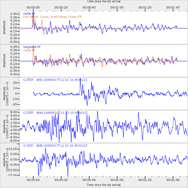
Signal To Noise
| Channel | StoN | STA | LTA |
| G:CRZF: :BHN:19960617T11:32:10.450012Z | 0.6628315 | 1.343828E-6 | 2.0274051E-6 |
| G:CRZF: :BHE:19960617T11:32:10.450012Z | 4.3050184 | 4.6344276E-6 | 1.0765175E-6 |
| G:CRZF: :BHZ:19960617T11:32:10.450012Z | 5.6629453 | 8.424844E-6 | 1.4877143E-6 |
| Arrivals |
| Ps | 12 SECOND |
| PpPs | 40 SECOND |
| PsPs/PpSs | 53 SECOND |


