You are here: Home > Network List > G - GEOSCOPE Stations List
> Station CRZF Port Alfred, Crozet, South Indian Ocean > Earthquake Result Viewer
CRZF Port Alfred, Crozet, South Indian Ocean - Earthquake Result Viewer
| Earthquake location: |
Santa Cruz Islands |
| Earthquake latitude/longitude: |
-12.9/166.5 |
| Earthquake time(UTC): |
1997/04/21 (111) 12:06:34 GMT |
| Earthquake Depth: |
33 km |
| Earthquake Magnitude: |
6.1 MB |
| Earthquake Catalog/Contributor: |
WHDF/NEIC |
|
| Network: |
G GEOSCOPE |
| Station: |
CRZF Port Alfred, Crozet, South Indian Ocean |
| Lat/Lon: |
46.43 S/51.86 E |
| Elevation: |
140 m |
|
| Distance: |
96.9 deg |
| Az: |
219.31 deg |
| Baz: |
116.725 deg |
| Ray Param: |
0.040348195 |
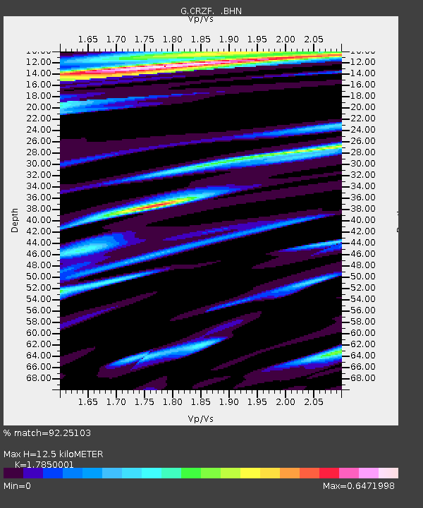
| Estimated Moho Depth: |
12.5 km |
| Estimated Crust Vp/Vs: |
1.79 |
| Assumed Crust Vp: |
4.802 km/s |
| Estimated Crust Vs: |
2.69 km/s |
| Estimated Crust Poisson's Ratio: |
0.27 |
|
| Radial Match: |
92.25103 % |
| Radial Bump: |
287 |
| Transverse Match: |
71.81707 % |
| Transverse Bump: |
378 |
| SOD ConfigId: |
6273 |
| Insert Time: |
2010-02-26 21:55:10.521 +0000 |
| GWidth: |
2.5 |
| Max Bumps: |
400 |
| Tol: |
0.001 |
|
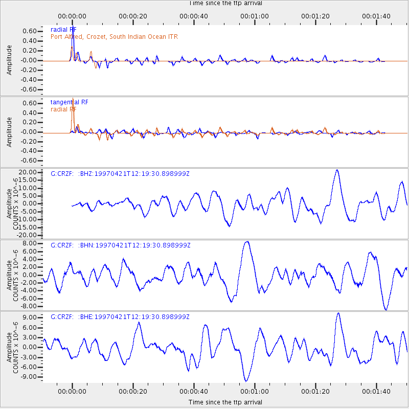
Signal To Noise
| Channel | StoN | STA | LTA |
| G:CRZF: :BHN:19970421T12:19:30.898999Z | 1.3335139 | 1.6477671E-6 | 1.235658E-6 |
| G:CRZF: :BHE:19970421T12:19:30.898999Z | 2.0786245 | 2.2066429E-6 | 1.0615881E-6 |
| G:CRZF: :BHZ:19970421T12:19:30.898999Z | 1.9451313 | 4.740603E-6 | 2.4371634E-6 |
| Arrivals |
| Ps | 2.1 SECOND |
| PpPs | 7.2 SECOND |
| PsPs/PpSs | 9.2 SECOND |


