You are here: Home > Network List > G - GEOSCOPE Stations List
> Station CRZF Port Alfred, Crozet, South Indian Ocean > Earthquake Result Viewer
CRZF Port Alfred, Crozet, South Indian Ocean - Earthquake Result Viewer
| Earthquake location: |
Near Coast Of Central Chile |
| Earthquake latitude/longitude: |
-30.9/-71.2 |
| Earthquake time(UTC): |
1997/10/15 (288) 01:03:33 GMT |
| Earthquake Depth: |
58 km |
| Earthquake Magnitude: |
6.8 MB, 6.8 MS, 7.3 UNKNOWN, 7.1 MW |
| Earthquake Catalog/Contributor: |
WHDF/NEIC |
|
| Network: |
G GEOSCOPE |
| Station: |
CRZF Port Alfred, Crozet, South Indian Ocean |
| Lat/Lon: |
46.43 S/51.86 E |
| Elevation: |
140 m |
|
| Distance: |
87.4 deg |
| Az: |
144.54 deg |
| Baz: |
226.114 deg |
| Ray Param: |
0.043238066 |
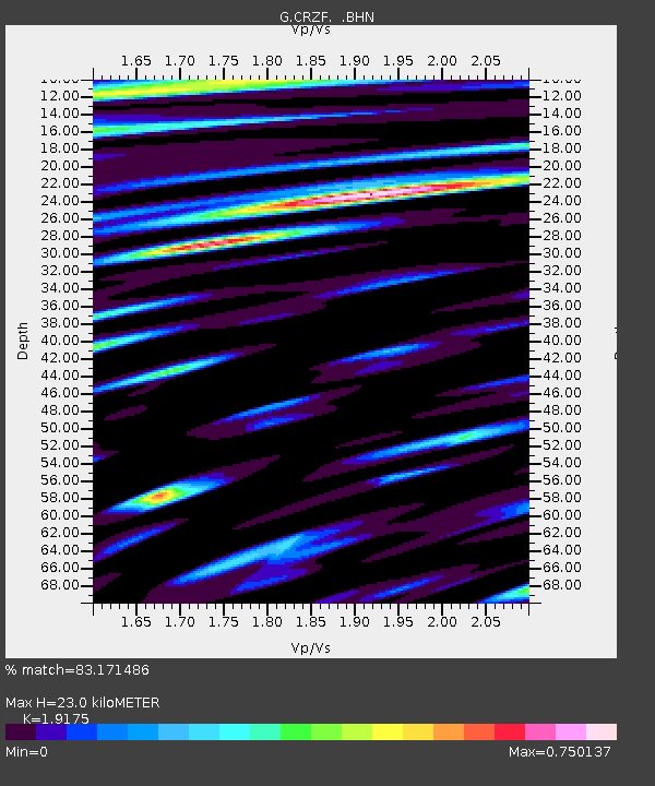
| Estimated Moho Depth: |
23.0 km |
| Estimated Crust Vp/Vs: |
1.92 |
| Assumed Crust Vp: |
4.802 km/s |
| Estimated Crust Vs: |
2.504 km/s |
| Estimated Crust Poisson's Ratio: |
0.31 |
|
| Radial Match: |
83.171486 % |
| Radial Bump: |
400 |
| Transverse Match: |
82.1685 % |
| Transverse Bump: |
400 |
| SOD ConfigId: |
6273 |
| Insert Time: |
2010-02-26 21:55:11.949 +0000 |
| GWidth: |
2.5 |
| Max Bumps: |
400 |
| Tol: |
0.001 |
|
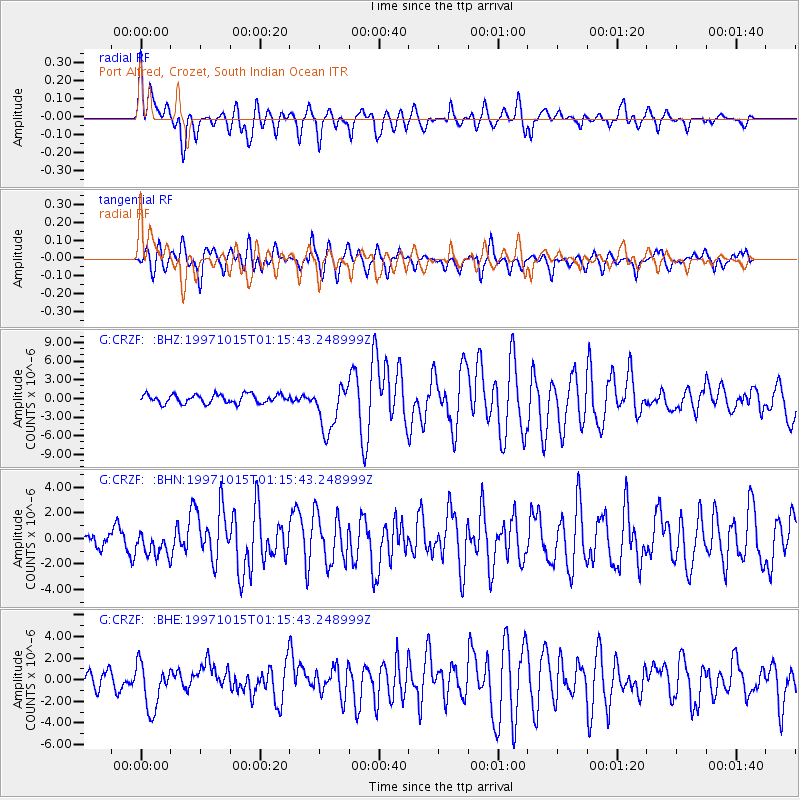
Signal To Noise
| Channel | StoN | STA | LTA |
| G:CRZF: :BHN:19971015T01:15:43.248999Z | 1.3430797 | 9.2627397E-7 | 6.896642E-7 |
| G:CRZF: :BHE:19971015T01:15:43.248999Z | 2.8769536 | 2.151193E-6 | 7.4773294E-7 |
| G:CRZF: :BHZ:19971015T01:15:43.248999Z | 5.273354 | 3.7255793E-6 | 7.064914E-7 |
| Arrivals |
| Ps | 4.4 SECOND |
| PpPs | 14 SECOND |
| PsPs/PpSs | 18 SECOND |


