You are here: Home > Network List > TA - USArray Transportable Network (new EarthScope stations) Stations List
> Station M04C Macdoel, CA, USA > Earthquake Result Viewer
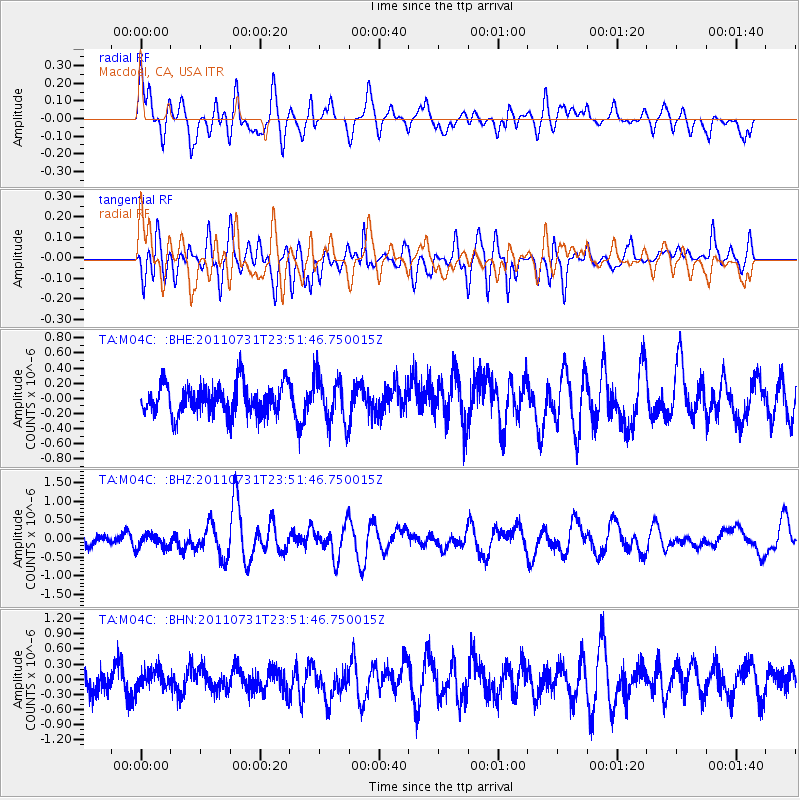
M04C Macdoel, CA, USA - Earthquake Result Viewer
*The percent match for this event was below the threshold and hence no stack was calculated.
| Earthquake location: |
Near N Coast Of New Guinea, P.N.G. |
| Earthquake latitude/longitude: |
-3.5/144.8 |
| Earthquake time(UTC): |
2011/07/31 (212) 23:38:56 GMT |
| Earthquake Depth: |
10 km |
| Earthquake Magnitude: |
6.2 MB, 6.6 MS, 6.6 MW, 6.6 MW |
| Earthquake Catalog/Contributor: |
WHDF/NEIC |
|
| Network: |
TA USArray Transportable Network (new EarthScope stations) |
| Station: |
M04C Macdoel, CA, USA |
| Lat/Lon: |
41.78 N/121.84 W |
| Elevation: |
1391 m |
|
| Distance: |
94.8 deg |
| Az: |
48.527 deg |
| Baz: |
269.594 deg |
| Ray Param: |
$rayparam |
*The percent match for this event was below the threshold and hence was not used in the summary stack. |
|
| Radial Match: |
54.62682 % |
| Radial Bump: |
400 |
| Transverse Match: |
58.957546 % |
| Transverse Bump: |
400 |
| SOD ConfigId: |
408116 |
| Insert Time: |
2012-01-01 02:17:06.728 +0000 |
| GWidth: |
2.5 |
| Max Bumps: |
400 |
| Tol: |
0.001 |
|
Signal To Noise
| Channel | StoN | STA | LTA |
| TA:M04C: :BHZ:20110731T23:51:46.750015Z | 1.57522 | 1.820714E-7 | 1.15584754E-7 |
| TA:M04C: :BHN:20110731T23:51:46.750015Z | 0.75579906 | 1.8276084E-7 | 2.4181142E-7 |
| TA:M04C: :BHE:20110731T23:51:46.750015Z | 1.5066879 | 2.998517E-7 | 1.9901381E-7 |
| Arrivals |
| Ps | |
| PpPs | |
| PsPs/PpSs | |


