You are here: Home > Network List > UW - Pacific Northwest Regional Seismic Network Stations List
> Station FISH Seaside, OR, USA > Earthquake Result Viewer
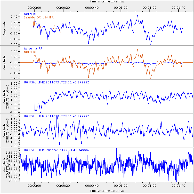
FISH Seaside, OR, USA - Earthquake Result Viewer
*The percent match for this event was below the threshold and hence no stack was calculated.
| Earthquake location: |
Near N Coast Of New Guinea, P.N.G. |
| Earthquake latitude/longitude: |
-3.5/144.8 |
| Earthquake time(UTC): |
2011/07/31 (212) 23:38:56 GMT |
| Earthquake Depth: |
10 km |
| Earthquake Magnitude: |
6.2 MB, 6.6 MS, 6.6 MW, 6.6 MW |
| Earthquake Catalog/Contributor: |
WHDF/NEIC |
|
| Network: |
UW Pacific Northwest Regional Seismic Network |
| Station: |
FISH Seaside, OR, USA |
| Lat/Lon: |
45.93 N/123.56 W |
| Elevation: |
325 m |
|
| Distance: |
93.6 deg |
| Az: |
44.352 deg |
| Baz: |
268.713 deg |
| Ray Param: |
$rayparam |
*The percent match for this event was below the threshold and hence was not used in the summary stack. |
|
| Radial Match: |
30.789558 % |
| Radial Bump: |
400 |
| Transverse Match: |
31.170782 % |
| Transverse Bump: |
400 |
| SOD ConfigId: |
408116 |
| Insert Time: |
2012-01-01 02:18:15.725 +0000 |
| GWidth: |
2.5 |
| Max Bumps: |
400 |
| Tol: |
0.001 |
|
Signal To Noise
| Channel | StoN | STA | LTA |
| UW:FISH: :BHZ:20110731T23:51:41.34999Z | 0.7209529 | 3.3249594E-7 | 4.6118956E-7 |
| UW:FISH: :BHN:20110731T23:51:41.34999Z | 0.9311906 | 5.702519E-9 | 6.123901E-9 |
| UW:FISH: :BHE:20110731T23:51:41.34999Z | 0.93361324 | 1.3412485E-6 | 1.4366212E-6 |
| Arrivals |
| Ps | |
| PpPs | |
| PsPs/PpSs | |


