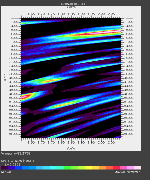
BERG Bagley Icefield - Earthquake Result Viewer

Earthquake location: Near N Coast Of New Guinea, P.N.G.
Earthquake latitude/longitude: -3.5/144.8
Earthquake time(UTC): 2011/07/31 (212) 23:38:56 GMT
Earthquake Depth: 10 km
Earthquake Magnitude: 6.2 MB, 6.6 MS, 6.6 MW, 6.6 MW
Earthquake Catalog/Contributor: WHDF/NEIC
Network: XZ STEEP: St. Elias Erosion and Tectonics Project
Station: BERG Bagley Icefield
Lat/Lon: 60.39 N/143.70 W
Elevation: 474 m
Distance: 84.0 deg
Az: 28.257 deg
Baz: 252.105 deg
Ray Param: 0.045790825
Estimated Moho Depth: 16.25 km
Estimated Crust Vp/Vs: 2.08
Assumed Crust Vp: 6.566 km/s
Estimated Crust Vs: 3.153 km/s
Estimated Crust Poisson's Ratio: 0.35
Radial Match: 83.2758 %
Radial Bump: 400
Transverse Match: 81.257935 %
Transverse Bump: 400
SOD ConfigId: 408116
Insert Time: 2012-01-01 02:18:38.080 +0000
GWidth: 2.5
Max Bumps: 400
Tol: 0.001

Signal To Noise

ChannelStoNSTALTA
XZ:BERG: :BHZ:20110731T23:50:55.547988Z2.77360653.6499603E-71.3159618E-7
XZ:BERG: :BHN:20110731T23:50:55.547988Z0.882430431.7496896E-71.9828074E-7
XZ:BERG: :BHE:20110731T23:50:55.547988Z1.29411181.8875753E-71.4585875E-7
Arrivals
Ps2.7 SECOND
PpPs7.5 SECOND
PsPs/PpSs10 SECOND